
Outlook:
Severe storms are expected in multiple rounds across Missouri, central/southern Illinois, and portions of Kentucky on Sunday. A round of severe storms in a line is expected to sweep through overnight Saturday into Sunday morning, followed by another more concentrated round of severe storms late Sunday afternoon into the evening hours. These storms will be capable of all hazard types, especially during the evening hours. For detailed information on timing, impacts, and more, refer below.
Overall Forecast:
The same mid-level trough that has enhanced and brought an outbreak of severe weather on Saturday is anticipated to continue to push eastward, eventually reaching the Midwest and Great Lakes region, affecting areas from Missouri through central/southern Illinois and portions of Kentucky.
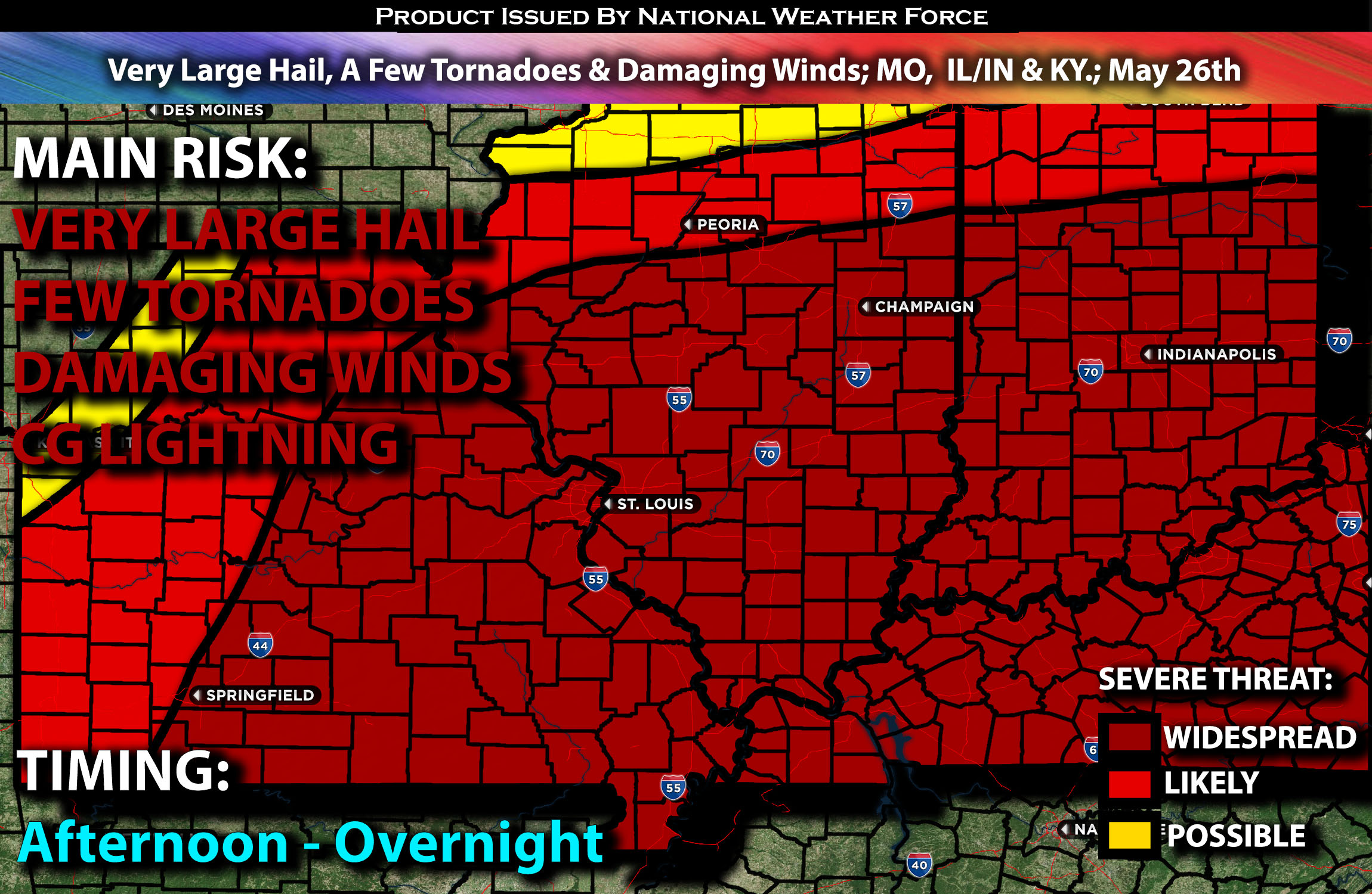
From Missouri Through Central/Southern Illinois/Indiana & Kentucky.:
At the surface, a low-pressure system will be located over the northern portions of Missouri, with an associated warm front to the east and a cold front attached. Ahead of this boundary, very moist warm air advection is expected. Combined with steep mid-level lapse rates (change in temperature with height) and 50 knots of effective shear from the shortwave trough, this will support a supercell storm mode with a primary threat of large hail. Additionally, strong low-level shear could enhance the tornado threat, especially if there is sufficient boundary layer recovery during the evening, particularly across southern Illinois and the surrounding vicinity.
Coverage Details:
A line of severe storms is anticipated to sweep across the region overnight into the morning hours, with the main risk being damaging winds and perhaps an embedded tornado if the right ingredients align. These storms will move out quickly, leading to atmospheric recovery. This will cause destabilization and result in a very unstable airmass once again over the area. More severe storms are expected to form as destabilization occurs during the late afternoon and into the evening hours, initially as discrete cells before eventually merging and becoming a QLCS (squall line) as it exits Illinois and moves into the Kentucky region.
Future Radar Scenario:
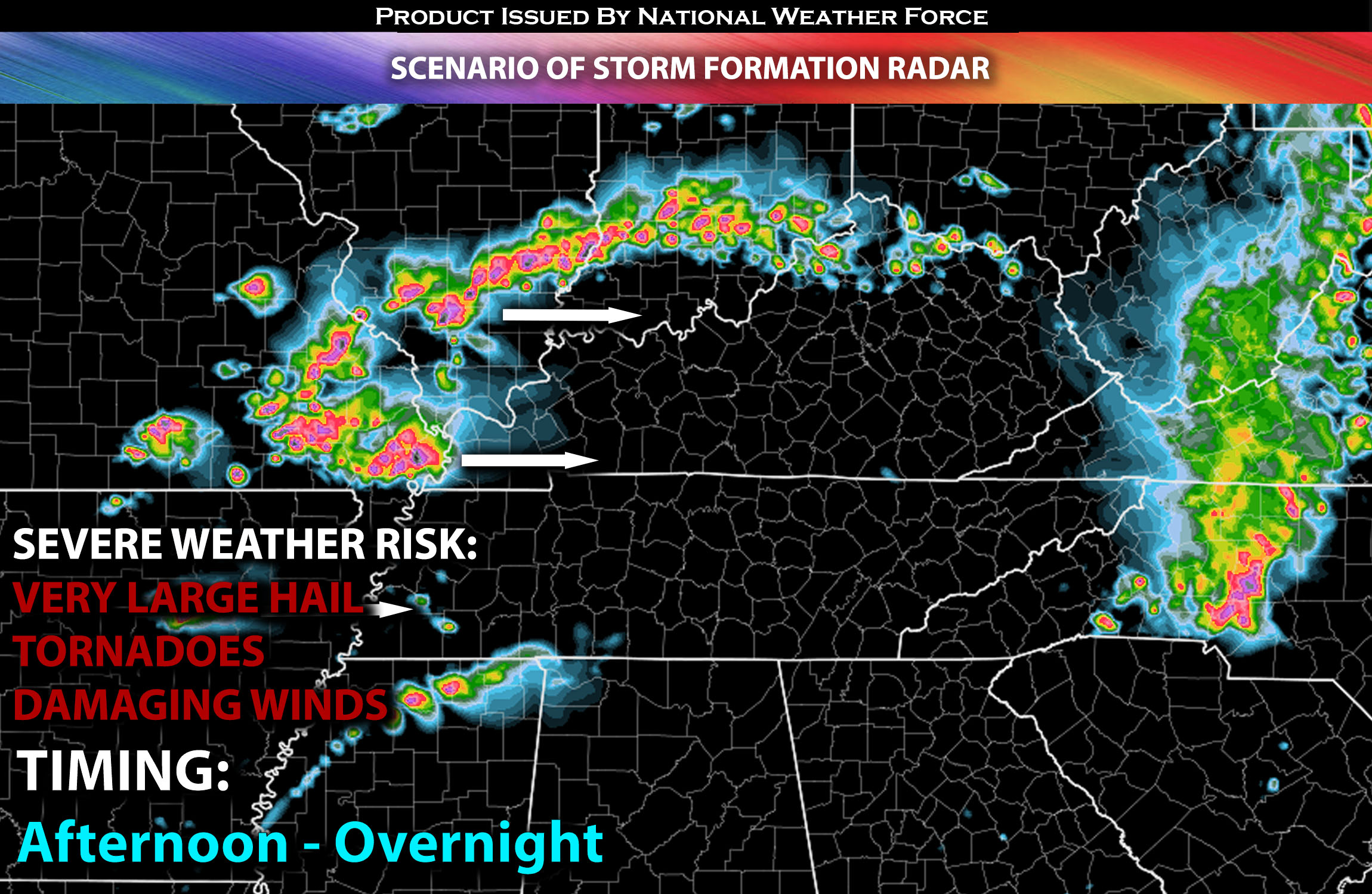 Main Risk: very large hail, a few tornadoes (if ingredients align), damaging winds and CG lightning (cloud to ground).
Stay tuned for more updates.
Sina⚡⚡
With over a decade of experience in forecasting severe thunderstorms, this individual is a seasoned forecaster and developer. Their expertise in severe weather forecasting and computer science is entirely self-taught, complemented by a foundation in Atmospheric Science from UNCO and an IT background from WGU. They have dedicated their efforts to developing innovative tools that enhance the accuracy of analyzing large hail and tornadoes. As a significant contributor and partner at National Weather Force Innovations LLC, they have played a crucial role in providing accurate and timely information. Additionally, they have been instrumental in developing tools and organizing projects that focus on accuracy and performance, ensuring those affected are well-informed.