
Outlook:
Severe storms are expected to be widespread in multiple rounds across Texas on Thursday, with damaging winds and very large hail being the main threat. An MCS is also anticipated to form later in the evening as well across TX especially. For detailed information on timing, impacts, and more, refer below.
Overall Forecast:
In the upper levels of the atmosphere, a trough will continue pushing eastward across the northern High Plains today, while west-northwesterly mid-level flow remains over the southern Plains. At the same time, a shortwave trough causing further lift will move into the southern High Plains during the day, with a moist and unstable airmass developing ahead of it.
Across the Southern/Central Plains:
In the upper levels of the atmosphere, a trough will continue pushing eastward across the northern High Plains today, while west-northwesterly mid-level flow remains over the southern Plains. At the same time, a shortwave trough causing further lift will move into the southern High Plains during the day, with a moist and unstable airmass developing ahead of it.
By the afternoon, a dryline will become prominent from southeast Colorado extending southward across far eastern New Mexico. As surface temperatures rise, scattered storms are expected to initiate along and east of the dryline. Storm coverage will increase late in the afternoon and early evening, likely leading to MCS development and more organized severe weather.
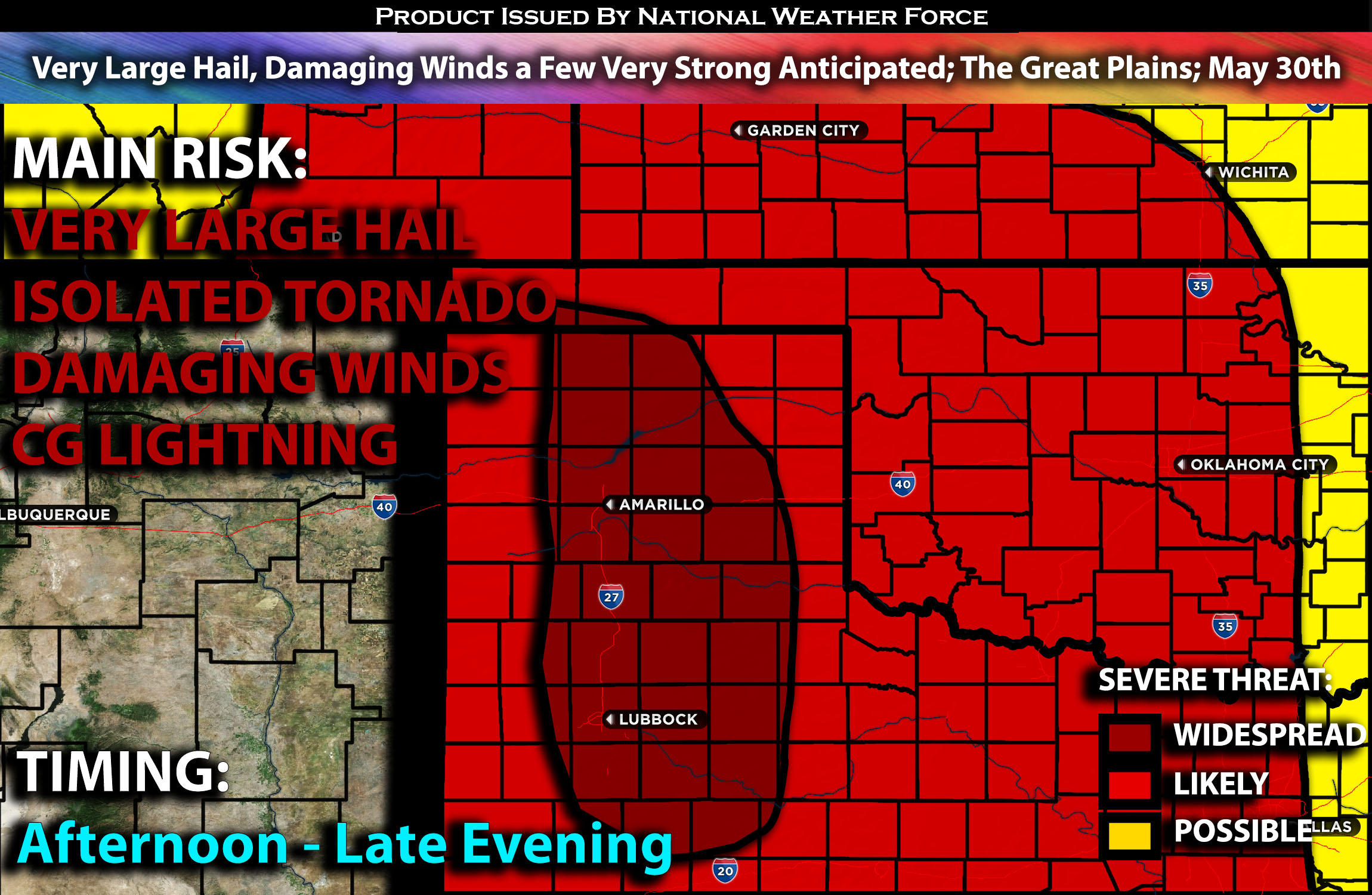
The airmass east of the dryline is anticipated to become moderately to strongly unstable by afternoon, with extreme instability expected by mid to late afternoon. Moisture levels will be sufficient, with dew points in the 50s. Deep effective layer shear around 40 knots, combined with steep mid-level lapse rates, will create an environment conducive to supercells with very large hail. As these cells mature, hailstones over 2-3 inches in diameter will be possible. The greatest threat for large hail is expected from near Amarillo southward to near Lubbock, where mid-level lapse rates and instability will be most favorable. An isolated tornado threat could also develop, depending on mesoscale factors, but the lack of low-level shear and moisture will be a limiting factor.
As the MCS organizes and moves eastward into western Oklahoma and the Texas during the evening, a mixed mode with supercell structures and linear mode expected. Severe wind gusts and isolated large hail will likely continue through much of the evening.
Coverage Details:
Storms are anticipated to form east of the dryline in the late afternoon in western Texas, stretching up through the Texas/Oklahoma Panhandle and portions of eastern Colorado. These storms will mature quickly, becoming severe and capable of producing large hail, damaging winds, and perhaps an isolated tornado if mesoscale conditions hold. The most concentrated risk for very large hail will be from Amarillo to Lubbock, Texas, where the ingredients are more favorable. An MCS is expected to form and continue into the late evening hours, pushing eastward.
Future Radar Scenario:
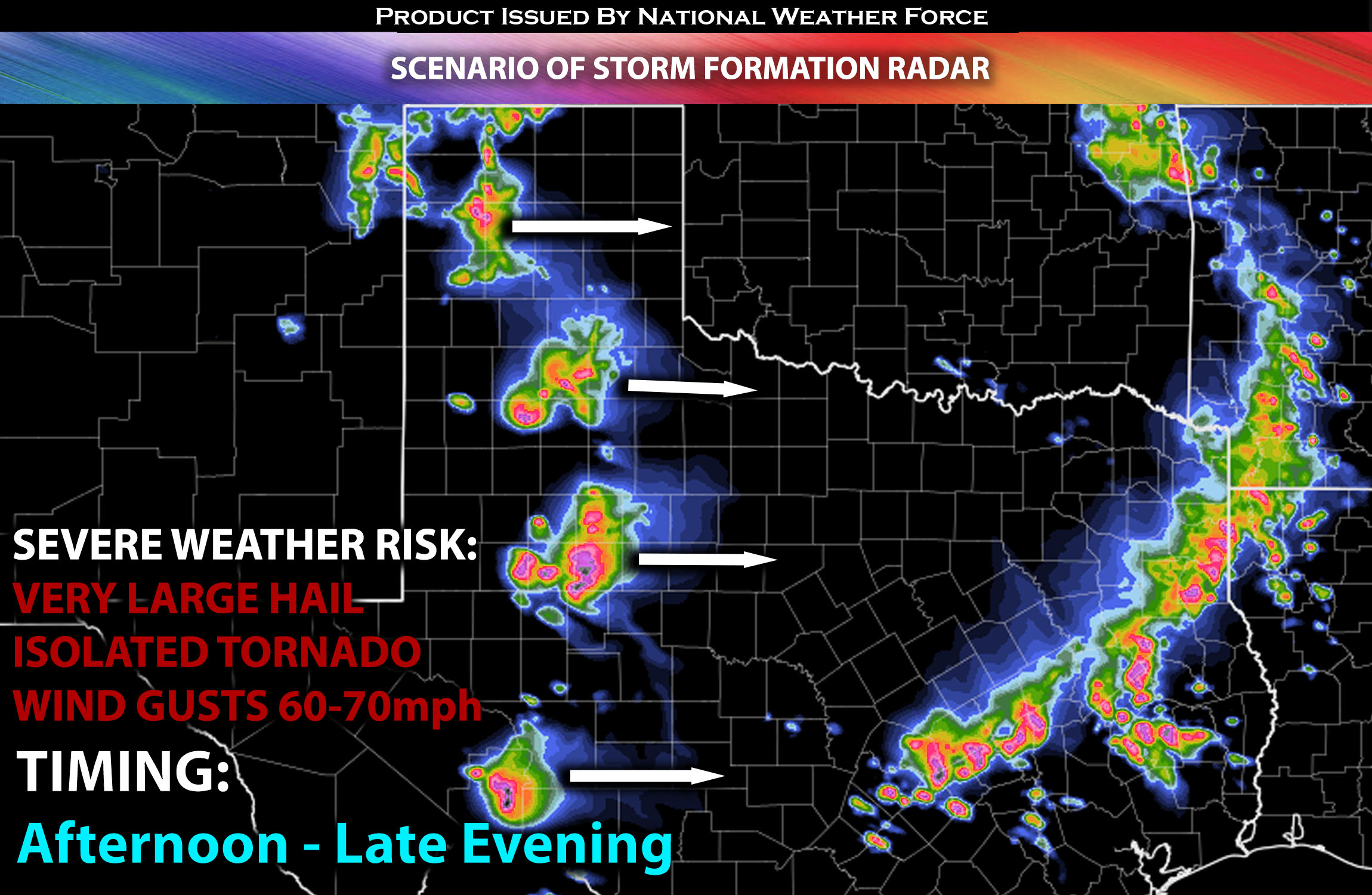
Main Risk: very large hail, very low risk for an isolated tornado, damaging winds and CG lightning (cloud to ground).
Stay tuned for more updates.
Sina⚡⚡
With over a decade of experience in forecasting severe thunderstorms, this individual is a seasoned forecaster and developer. Their expertise in severe weather forecasting and computer science is entirely self-taught, complemented by a foundation in Atmospheric Science from UNCO and an IT background from WGU. They have dedicated their efforts to developing innovative tools that enhance the accuracy of analyzing large hail and tornadoes. As a significant contributor and partner at National Weather Force Innovations LLC, they have played a crucial role in providing accurate and timely information. Additionally, they have been instrumental in developing tools and organizing projects that focus on accuracy and performance, ensuring those affected are well-informed.