
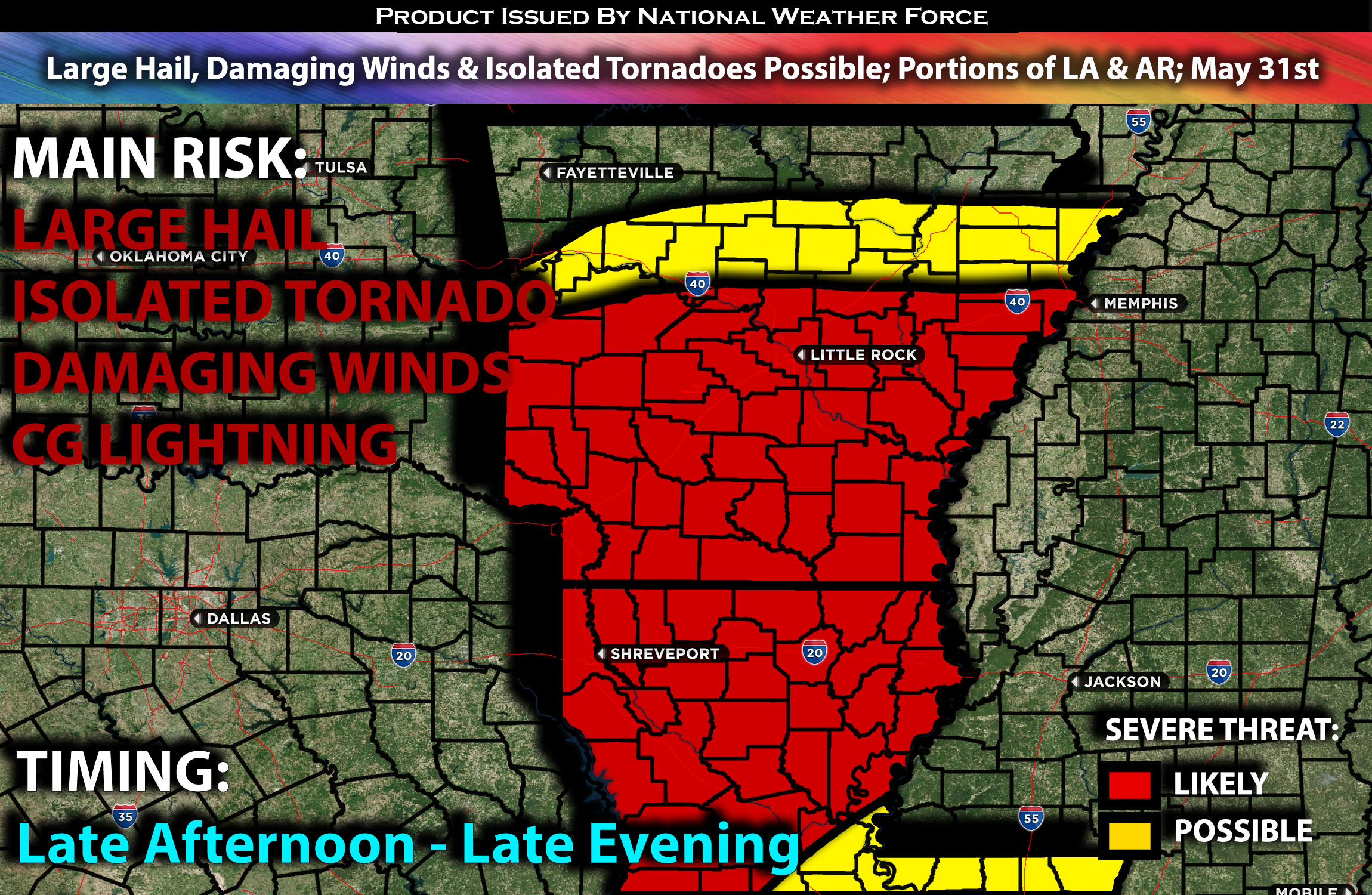
Outlook:
Severe storms are anticipated across Louisiana and into Arkansas, particularly in the southern portions, late in the afternoon. These storms will pose a risk for large hail and isolated tornadoes, especially if they remain discrete. For detailed information on timing, impacts, and more, refer below.
Overall Forecast:
In the upper levels of the atmosphere, a trough will move slowly eastward across the central U.S. Concurrently, low-level moisture advection will occur as the upper-level trough approaches. By afternoon, surface dewpoints are forecast to be in the mid to upper 60s F from northern Louisiana into Arkansas. Surface heating and increasing large-scale ascent ahead of the trough will likely support scattered thunderstorm development.
Across Arkansas and Louisiana:
By late afternoon, instability is expected to be strong across Arkansas and northern Louisiana, with effective mid-layer shear in the 30s. These conditions will support a severe threat, particularly with the stronger cells. If discrete storm modes can be maintained, there will be a risk for isolated tornadoes in parts of northern Louisiana and southern Arkansas, along the southern edge of the stronger low-level flow. Across most of the region, wind damage will be the primary threat, with this potential continuing into the early to mid-evening.
Coverage Details:
Around late afternoon, storms are expected to form across Louisiana and into south-central Arkansas, continuing to strengthen rapidly while remaining mostly discrete. Some of these storms may potentially produce isolated tornadoes if they can maintain their mesoscale structure through the late evening.
Main Risk: large hail, isolated tornadoes, damaging winds and CG lightning (cloud to ground).
Stay tuned for more updates.
Sina⚡⚡
With over a decade of experience in forecasting severe thunderstorms, this individual is a seasoned forecaster and developer. Their expertise in severe weather forecasting and computer science is entirely self-taught, complemented by a foundation in Atmospheric Science from UNCO and an IT background from WGU. They have dedicated their efforts to developing innovative tools that enhance the accuracy of analyzing large hail and tornadoes. As a significant contributor and partner at National Weather Force Innovations LLC, they have played a crucial role in providing accurate and timely information. Additionally, they have been instrumental in developing tools and organizing projects that focus on accuracy and performance, ensuring those affected are well-informed.