
 Outlook:
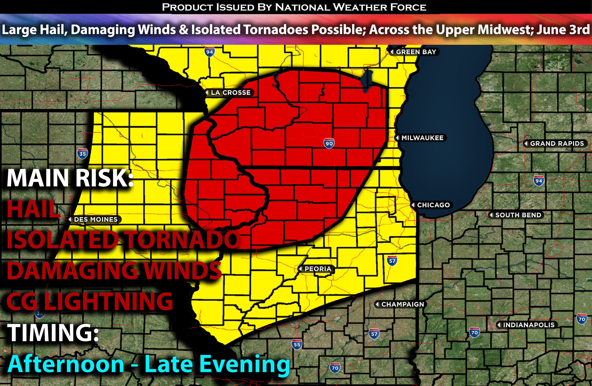
Severe storms are anticipated across portions of the Midwest this afternoon and evening, particularly in northern Illinois and southern Wisconsin. These storms will pose a risk for hail, damaging winds, and isolated tornadoes, especially if they remain discrete. For detailed information on timing, impacts, and more, refer below. For detailed information on timing, impacts, and more, refer below.
Overall Forecast:
In the mid-levels of the atmosphere, zonal flow, coupled with a series of mesoscale features (systems from the previous night), will shape the potential for severe thunderstorms today and tonight. Currently, a shortwave trough over the mid-Missouri Valley is expected to move into the upper Midwest by early afternoon which will be the key to this setup.
Across the Upper Midwest:
Deep low-level moisture will be present ahead of the MCV system. Clearing skies should allow for sufficient daytime heating to support moderate destabilization from eastern Iowa into southern Wisconsin and northern Illinois, despite relatively poor mid-level lapse rates. Weak convergence and some ascent from the shortwave should lead to scattered thunderstorms by early afternoon. Although deep-layer shear will not be particularly strong, the enhancement in lift across an unstable airmass from the MCV may support organized multi cells with the potential for some discrete supercells as well. These storms will be capable of producing damaging wind gusts, hail, and isolated tornadoes given the potential shift in winds with height.
Coverage Details:
Storms are expected to form ahead of the MCV from late afternoon through the evening hours. These storms will be multi cells with the potential for a few discrete cells capable of producing all hazard types. A few of these storms will also have a brief risk of isolated tornadoes, given the present ingredients. These storms will move northeastward, depending on the position of the MCV, before shifting direction as the MCV moves through.
Main Risk: large hail, isolated tornadoes, damaging winds and CG lightning (cloud to ground).
Stay tuned for more updates.
Sina⚡⚡
With over a decade of experience in forecasting severe thunderstorms, this individual is a seasoned forecaster and developer. Their expertise in severe weather forecasting and computer science is entirely self-taught, complemented by a foundation in Atmospheric Science from UNCO and an IT background from WGU. They have dedicated their efforts to developing innovative tools that enhance the accuracy of analyzing large hail and tornadoes. As a significant contributor and partner at National Weather Force Innovations LLC, they have played a crucial role in providing accurate and timely information. Additionally, they have been instrumental in developing tools and organizing projects that focus on accuracy and performance, ensuring those affected are well-informed.