
 Outlook:
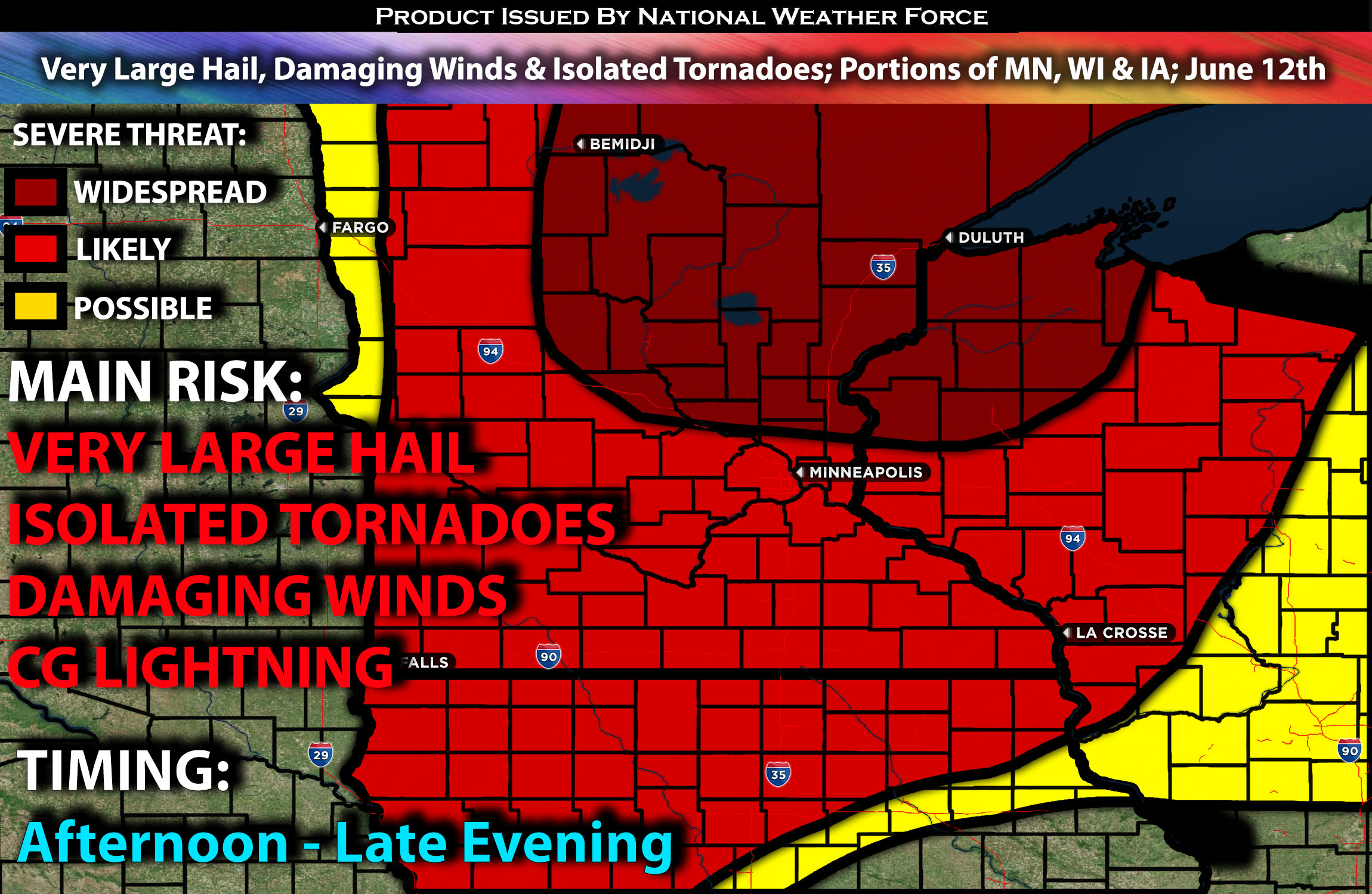
Scattered severe storms capable of producing very large hail, damaging wind gusts, and a few tornadoes will be possible across parts of the Upper Midwest on Wednesday, especially during the late afternoon through the evening hours. These storms may linger into the overnight hours as an MCS forms. For detailed information on timing, impacts, and more, refer below. For detailed information on timing, impacts, and more, refer below.
Overall Forecast:
A relatively complex convective scenario is expected to unfold on Wednesday, with multiple rounds of severe weather anticipated across Minnesota, especially.
A fast, largely zonal upper jet will spread into North Dakota and northern Minnesota by early Thursday. Concurrently, a shortwave trough will move through the region. A surface cyclone is also expected to be near the northern portions of the Minnesota border by Wednesday evening. Ahead of this, low-level warm advection will create a very unstable airmass.
Across Portions Iowa into Minnesota & Wisconsin:
Isolated storms are expected mainly over central eastern South Dakota into southwest Minnesota.
The main risk of severe storms will be ahead of the approaching cold front/boundary in northwest Minnesota to eastern South Dakota. A confined plume of moderately large buoyancy should develop by peak heating, with very strong instability expected over the region. The southwesterly low-level shear, coupled with gradually veering to west-northwesterly (and strengthening) upper-level winds, will favor discrete supercells across northern Minnesota initially before clustering into the evening given the veering of winds with the boundary.
Further south, more linear and less organized types of storms are expected, with the primary risks being damaging winds and large hail, although isolated tornadoes will also be a risk, but more likely embedded within the line. There will also be storms anticipated in portions of Iowa with the lower side of the line of storms. With greater buoyancy/instability to the west, the western portion of an evening cluster/MCS should contain the primary large hail/severe wind threat before storms start to dissipate overnight.
Coverage Details:
Ongoing storms are expected through the morning hours before the main severe weather occurs in the afternoon. Severe storms are anticipated from central Minnesota, with the more concentrated severe storms likely being discrete in the northern portions of Minnesota through the evening hours.
Future Radar Scenario:
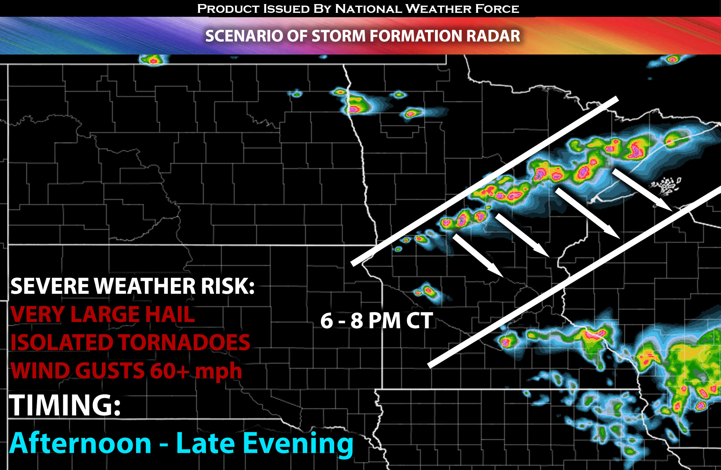 Main Risk: very large hail, damaging winds, isolated tornadoes and CG (cloud to ground) lightning.
Stay tuned for more updates.
Sina⚡⚡
With over a decade of experience in forecasting severe thunderstorms, this individual is a seasoned forecaster and developer. Their expertise in severe weather forecasting and computer science is entirely self-taught, complemented by a foundation in Atmospheric Science from UNCO and an IT background from WGU. They have dedicated their efforts to developing innovative tools that enhance the accuracy of analyzing large hail and tornadoes. As a significant contributor and partner at National Weather Force Innovations LLC, they have played a crucial role in providing accurate and timely information. Additionally, they have been instrumental in developing tools and organizing projects that focus on accuracy and performance, ensuring those affected are well-informed.