
Outlook:
Severe storms are anticipated to form as a disturbance moves through an unstable airmass across the Upper Midwest on Saturday. These storms will be capable of producing isolated hail, damaging winds, and isolated tornadoes if conditions align. For detailed information on timing, impacts, and more, refer below.
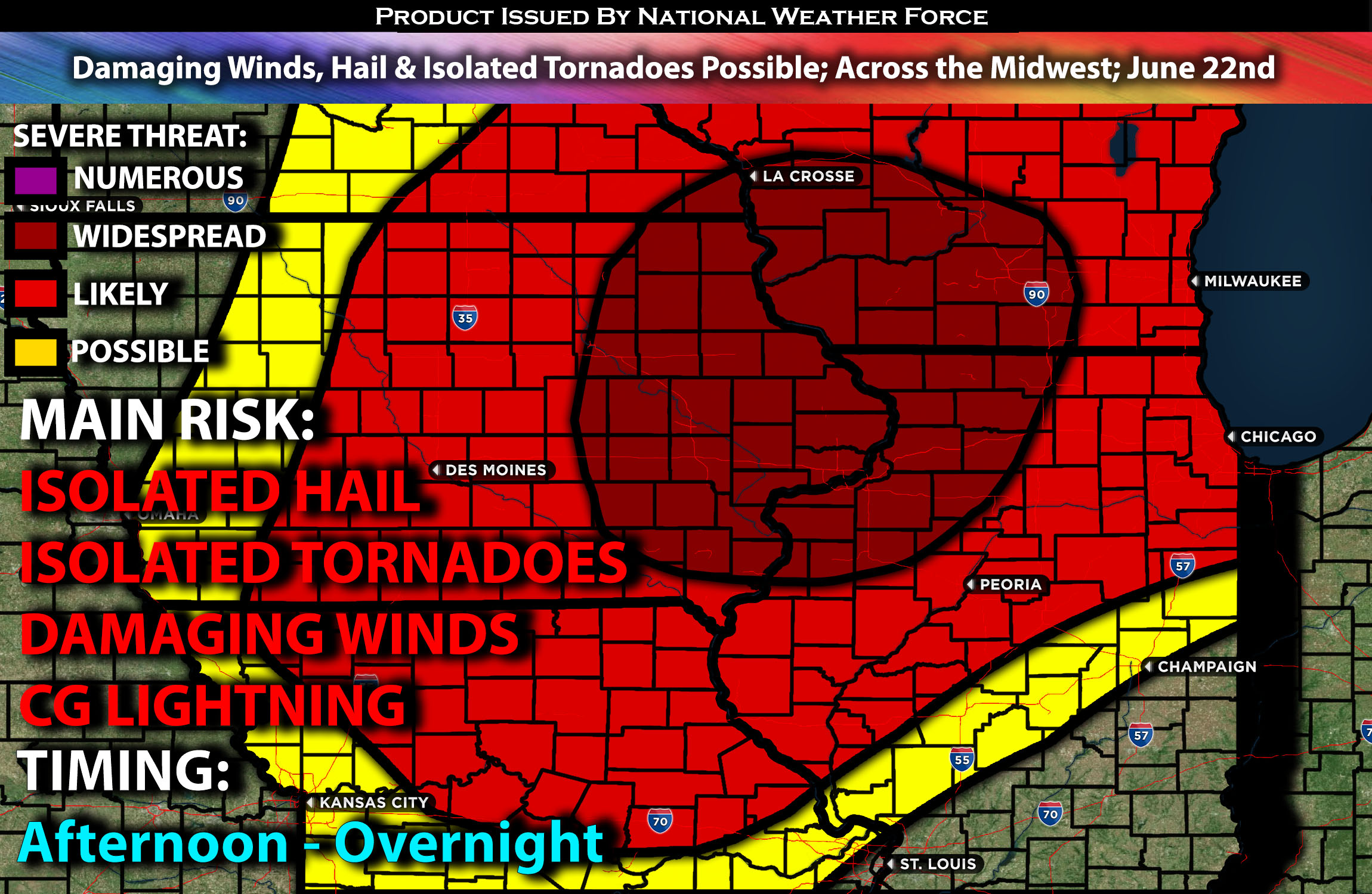
Overall Forecast for the Midwest:
A mid-level disturbance will move east into Michigan from morning to early afternoon, bringing showers and thunderstorms. There is a localized risk of strong to severe storms, especially in northern Lower Michigan due to heating and destabilization.
After the morning storms, moderate to strong instability is expected to develop from eastern Kansas and southeast Nebraska, stretching northeast into southern Wisconsin and northern Illinois. This will occur along and south of a front. Scattered to numerous thunderstorms are expected to form along this front by late afternoon into the evening, from northern Missouri to the Lake Michigan area.
As these storms push forward, they will move through an area with effective shear in the 30-40 knot range, allowing them to organize into cells and clusters. Additionally, strong heating and high moisture content will favor strong to damaging wind gusts as the primary threat. Warm temperatures in the mid-levels of the atmosphere will limit the overall instability and reduce the hail risk with stronger storms. However, a tornado or two is still possible due to moderate low-level southwesterly winds and low-level shear.
Coverage Details:
As destabilization occurs around 2 PM CT ahead of the front, storms are expected to form across Iowa, especially in central and northern portions, extending into parts of Minnesota. These storms will likely form a cluster as they move east into southern portions of Wisconsin, stretching down into western parts of Illinois. Eventually, they will move east-southeast, sweeping across extreme southern portions of Wisconsin and through the bite of Illinois. The storms will weaken quickly as they pass through Chicago and move southeastward, dissipating overnight.
Main Risk: isolated hail, damaging winds, isolated tornadoes and CG (cloud to ground) lightning.
Stay tuned for more updates.
Sina⚡⚡
With over a decade of experience in forecasting severe thunderstorms, this individual is a seasoned forecaster and developer. Their expertise in severe weather forecasting and computer science is entirely self-taught, complemented by a foundation in Atmospheric Science from UNCO and an IT background from WGU. They have dedicated their efforts to developing innovative tools that enhance the accuracy of analyzing large hail and tornadoes. As a significant contributor and partner at National Weather Force Innovations LLC, they have played a crucial role in providing accurate and timely information. Additionally, they have been instrumental in developing tools and organizing projects that focus on accuracy and performance, ensuring those affected are well-informed.