
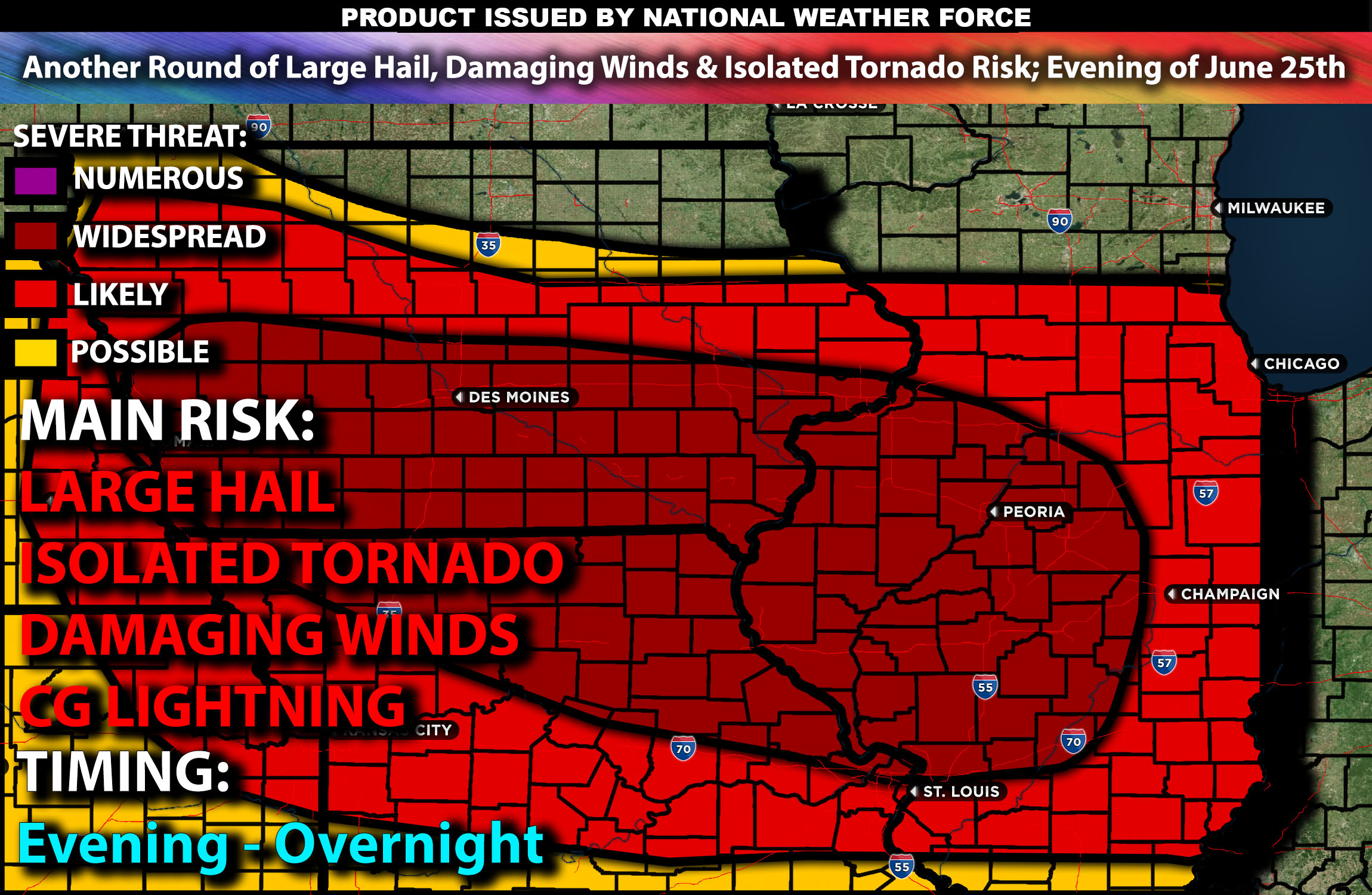
Outlook:
Severe storms are anticipated to form as a disturbance moves through an unstable airmass across the Central Plains and portions of the Midwest on Tuesday evening through the overnight hours. These storms will be capable of producing large hail, damaging winds, and isolated tornadoes if conditions align. For detailed information on timing, impacts, and more, refer below.
Overall Forecast from Central Plains Stretching to the Midwest:
An ongoing line of storms is currently moving through northern Illinois, stretching into Indiana and moving south southeastward. These storms are primarily capable of producing damaging winds and localized hail. They will continue into Indiana before fizzling out and slowly diminishing into the afternoon.
There will be more disturbances in a very unstable airmass, with steep temperature changes in the mid-levels and very high instability expected (3000-4500 J/kg) from northern Illinois across Iowa and eastern Nebraska. As a surface low pressure system moves in, it will help break a minor cap, allowing storms to form.
From late afternoon into early evening, conditions will be most favorable, with effective shear magnitudes of 30-40 knots. This environment will support organized multicell storms, a few supercells, and clusters of storms moving southward to southeastward over the lower Missouri and mid-Mississippi Valley regions. As these storms organize this evening, the initial mixed-type threats (hail, wind, tornadoes) will likely evolve towards damaging wind gusts. Specific areas for storm development remain uncertain due to weak low-level flow and subtle forcing mechanisms in this area.
Coverage Details:
As destabilization occurs across the south-southeastward boundary, storms are expected to pop up in the evening from northern/central Illinois through Iowa and portions of northern Missouri. These storms will continue in clusters with a few discrete cells embedded within them. Over time, they will collide, forming lines that move south-southeastward, particularly through Illinois, with another cluster becoming a line through Iowa, continuing through the night and into the early morning hours.
Main Risk: large hail, damaging winds, isolated tornadoes and CG (cloud to ground) lightning.
Stay tuned for more updates.
Sina⚡⚡
With over a decade of experience in forecasting severe thunderstorms, this individual is a seasoned forecaster and developer. Their expertise in severe weather forecasting and computer science is entirely self-taught, complemented by a foundation in Atmospheric Science from UNCO and an IT background from WGU. They have dedicated their efforts to developing innovative tools that enhance the accuracy of analyzing large hail and tornadoes. As a significant contributor and partner at National Weather Force Innovations LLC, they have played a crucial role in providing accurate and timely information. Additionally, they have been instrumental in developing tools and organizing projects that focus on accuracy and performance, ensuring those affected are well-informed.