
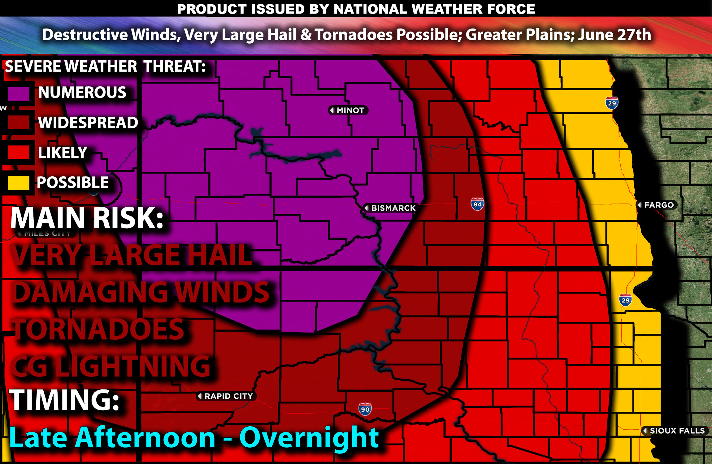
Outlook:
Multiple rounds of severe storms are anticipated as a disturbance moves through an unstable airmass across the Greater Plains from this afternoon through the overnight hours. These storms will be capable of producing very large hail, destructive gusty winds, and a few tornadoes if conditions align. For detailed information on timing, impacts, and more, refer below.
Detailed Forecast Across the Greater Plains:
Today, an upper ridge will start over the northern High Plains but will flatten and move eastward as a shortwave trough moves across the northern Rockies. This change will cause a surface low-pressure system to deepen over eastern Montana during the day and move into the western Dakotas by evening. A cold front will push east across the region overnight, with a surface trough/dryline extending south from the low across the northern and central High Plains.
South/southeasterly winds will bring moist air with dewpoints in the low to mid 60s°F northward across Kansas, Nebraska, and into the Dakotas and eastern Montana. Cooling air aloft and steepening lapse rates (change in temperature with height) will create strong instability. The wind profiles suggest that supercells could form in the afternoon, especially at first before becoming more linear later on.
The first storms are likely to develop over higher terrain and near the surface low in Montana, then extend south along the dryline in areas with strong low-level convergence. As the evening progresses, a southerly low-level jet will strengthen, leading to thunderstorm clusters that could grow into smaller bowing MCSs (Mesoscale Convective Systems) from far eastern Montana and the western Dakotas, possibly reaching western Nebraska.
The large instability, combined with steep low-level lapse rates and some dry air above 700 mb, will support strong downdrafts capable of producing severe wind gusts. There is also a chance for large to very large hail, especially with any supercells. As the low-level jet strengthens in the evening, the risk for a few tornadoes will increase, particularly near the surface low, mainly between 5 PM and 9 PM MDT. The main risk will continue to be powerful gusty winds in excess of 80 mph.
Coverage Details:
Storms are expected to form across the higher terrain near the surface low in Montana, stretching south along the dryline in the late afternoon. These storms will quickly become severe as they move through the unstable airmass. Initially, the storms will be more discrete before clustering together. Eventually, an MCS is expected to form across North Dakota and into portions of South Dakota, moving eastward throughout the evening. Additional clusters are also expected to form across South Dakota with outflow boundaries throughout the night.
Future Radar Scenario:
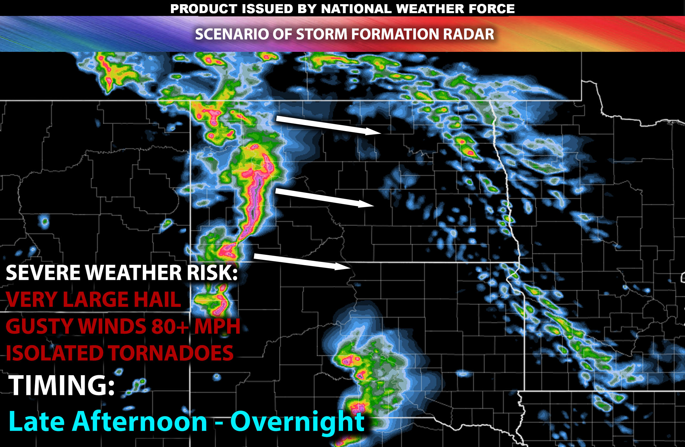
Main Risk: very large hail, destructive gusty winds, a few tornadoes and CG (cloud to ground) lightning.
Stay tuned for more updates.
Sina⚡⚡
With over a decade of experience in forecasting severe thunderstorms, this individual is a seasoned forecaster and developer. Their expertise in severe weather forecasting and computer science is entirely self-taught, complemented by a foundation in Atmospheric Science from UNCO and an IT background from WGU. They have dedicated their efforts to developing innovative tools that enhance the accuracy of analyzing large hail and tornadoes. As a significant contributor and partner at National Weather Force Innovations LLC, they have played a crucial role in providing accurate and timely information. Additionally, they have been instrumental in developing tools and organizing projects that focus on accuracy and performance, ensuring those affected are well-informed.