
 Outlook:
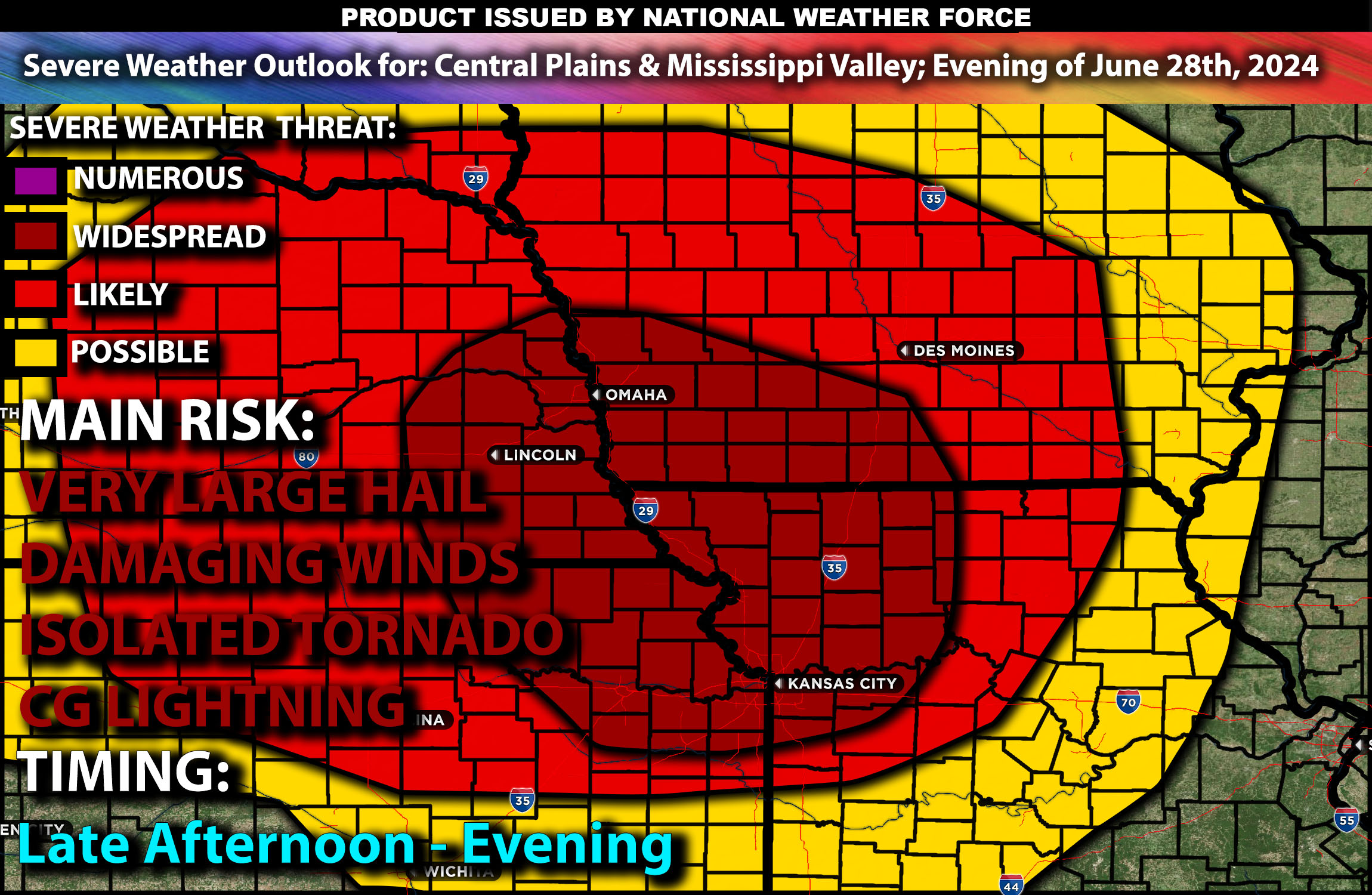
Multiple rounds of severe storms are anticipated as a disturbance moves through an unstable airmass across portions of the central Plains and the Mississippi Valley from this afternoon through the overnight hours. These storms will be capable of producing very large hail, destructive gusty winds, and isolated tornadoes if conditions align. For detailed information on timing, impacts, and more, refer below.
Detailed Forecast Across the Central Greater Plains through Mississippi Valley
An upper trough over the northern Rockies will move east toward the Upper Midwest and Great Lakes region. By Friday morning, a convectively concentrated weather system will move east toward Lake Michigan by evening. At the surface, an area of low pressure will be near the international border in North Dakota and southern Saskatchewan, shifting east into northern Minnesota and eventually the Upper Peninsula of Michigan and Lake Superior. As this happens, a cold front will move southeast across the northern Plains and Upper Midwest, guiding the airmass further south.
A secondary area of low pressure may develop near western/central Kansas due to intense heating over the southern Plains. Moist air will be present from the central Plains to the Mid-Mississippi Valley and into portions of the Midwest. Steep mid-level lapse rates will assist with strong instability over the region, and dry air in the lower mid-levels will support powerful gusty winds driven by strong downdrafts, potentially exceeding 75-80 mph in some stronger cells. Another risk will be very large hail given the energy present in the storms. If discrete cells can maintain strength with the right ingredients, isolated tornadoes are also possible, especially in northwestern Missouri and northeastern Kansas.
Coverage Details:
As destabilization occurs, storms are expected to form across portions of the central Plains into Missouri and surrounding areas by late afternoon. Initial storms will be more discrete, capable of producing damaging gusty winds, very large hail, and isolated tornadoes before diminishing quickly into the late evening across Missouri.
Main Risk: very large hail, destructive gusty winds, a few tornadoes and CG (cloud to ground) lightning.
Stay tuned for more updates.
Sina⚡⚡
With over a decade of experience in forecasting severe thunderstorms, this individual is a seasoned forecaster and developer. Their expertise in severe weather forecasting and computer science is entirely self-taught, complemented by a foundation in Atmospheric Science from UNCO and an IT background from WGU. They have dedicated their efforts to developing innovative tools that enhance the accuracy of analyzing large hail and tornadoes. As a significant contributor and partner at National Weather Force Innovations LLC, they have played a crucial role in providing accurate and timely information. Additionally, they have been instrumental in developing tools and organizing projects that focus on accuracy and performance, ensuring those affected are well-informed.