
Outlook:
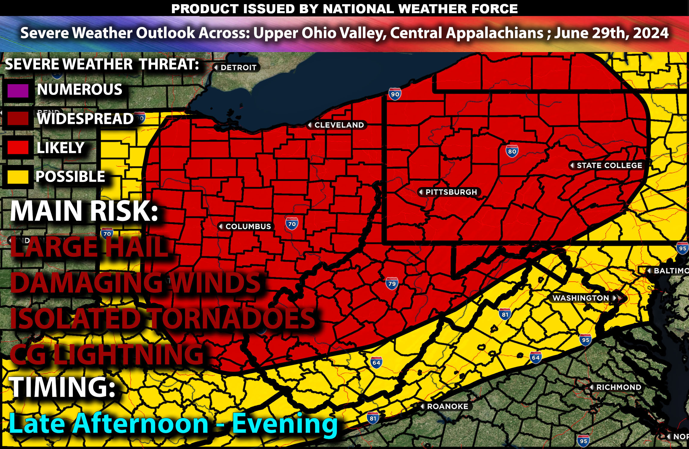
Severe thunderstorms are expected from the Upper Ohio Valley through the central Appalachians to the Lower Great Lakes, with damaging winds, large hail, and a couple of tornadoes likely, especially in areas like Columbus, Pittsburgh, and Buffalo, peaking from mid-afternoon to early evening. For detailed information on timing, impacts, and more, refer below.
States and Cities Impacted: Ohio (Columbus, Cleveland), Pennsylvania (Pittsburgh), West Virginia (Charleston), New York (Buffalo).
Detailed Forecast Across Upper Ohio Valley, Central Appalachians, and Lower Great Lakes:
Severe thunderstorms are anticipated to develop from the Upper Ohio Valley through the central Appalachians and into the Lower Great Lakes. The main threats in these areas are damaging winds, large hail, and the potential for a couple of tornadoes. Warm, moist air from the Gulf of Mexico will create an unstable atmosphere. Expect storms to form in the early afternoon, peaking from mid-afternoon to early evening as the day heats up. Supercells may form within storm clusters, particularly affecting areas such as Columbus, Pittsburgh, and Buffalo. This activity is driven by an upper-level trough advancing eastward, increasing wind shear and instability across the region.
Coverage Details:
In the morning expect ongoing showers and thunderstorms in parts of the Upper Ohio Valley. During the afternoon, severe thunderstorms will likely initiate by early afternoon, intensifying through mid to late afternoon. Then during the evening, peak severe weather activity is expected from mid-afternoon to early evening, with storms diminishing in intensity by late evening.
Main Risk: large hail, damaging winds, a few tornadoes and CG (cloud to ground) lightning.
Stay tuned for more updates.
Sina⚡⚡
With over a decade of experience in forecasting severe thunderstorms, this individual is a seasoned forecaster and developer. Their expertise in severe weather forecasting and computer science is entirely self-taught, complemented by a foundation in Atmospheric Science from UNCO and an IT background from WGU. They have dedicated their efforts to developing innovative tools that enhance the accuracy of analyzing large hail and tornadoes. As a significant contributor and partner at National Weather Force Innovations LLC, they have played a crucial role in providing accurate and timely information. Additionally, they have been instrumental in developing tools and organizing projects that focus on accuracy and performance, ensuring those affected are well-informed.