
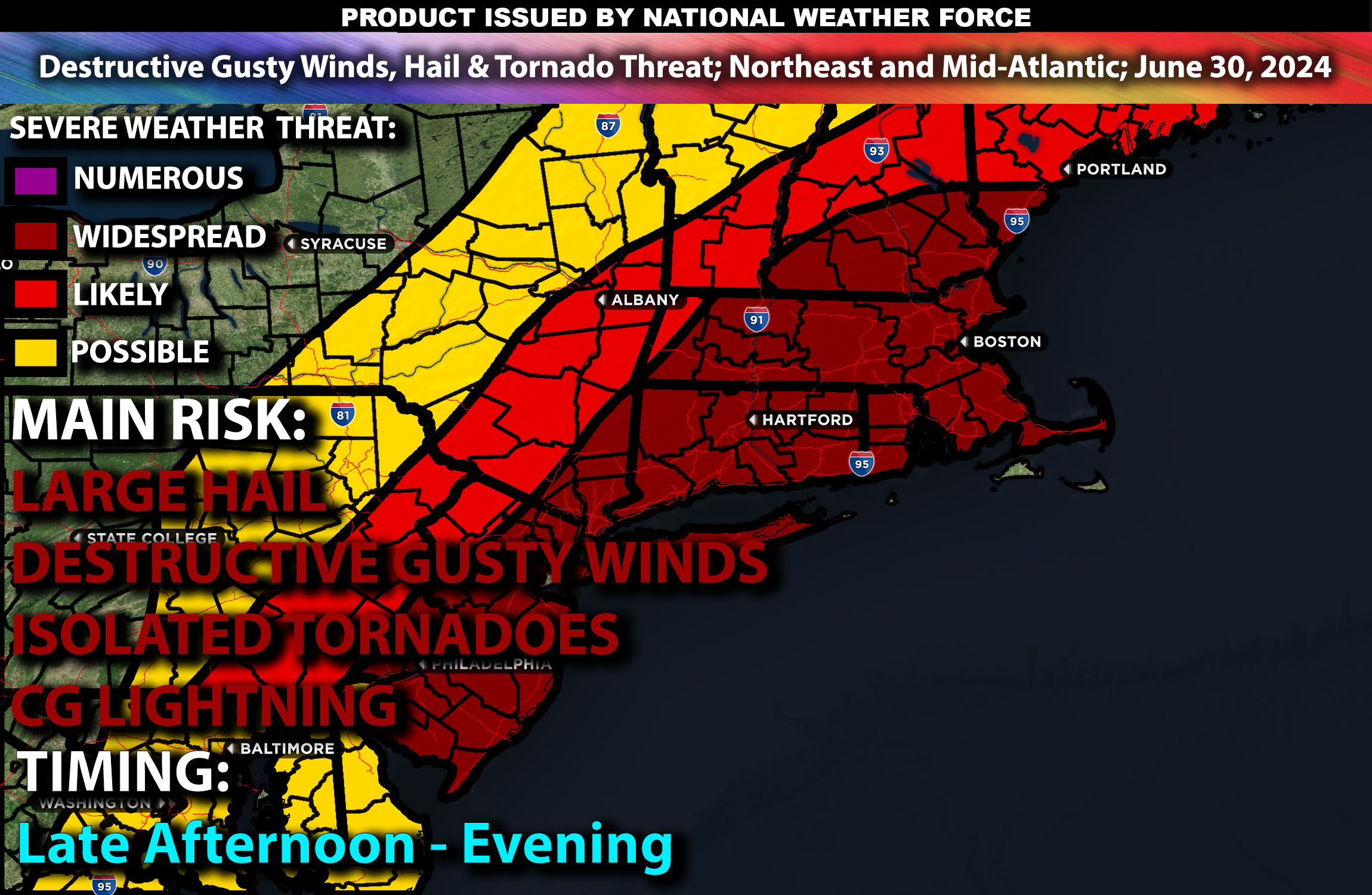
Brief Outlook:
Scattered severe thunderstorms are expected in the Northeast and Mid-Atlantic, posing risks of damaging winds, hail, and a few tornadoes. For detailed information on timing, impacts, and more, refer below.
States and Cities Impacted: New York (Buffalo, Syracuse), Pennsylvania (Philadelphia, Pittsburgh), Maryland (Baltimore), Virginia (Richmond).
Detailed Forecast:
An upper-level trough will move eastward from the Great Lakes into the Northeast, bringing a primary mid-level jet stream with very fast winds sweeping across northern New England. This feature will provide strong mid and high-level wind fields and shear, creating conditions conducive to severe thunderstorm development. Enhanced wind shear, especially in the mid and upper levels, will support organized storm structures, including supercells, particularly in northern New England where hail and possibly a couple of tornadoes could occur.
At the surface, instability values will exceed 3000 J/kg by midday, especially across Pennsylvania and into the Mid-Atlantic. The interaction between the advancing trough and the warm, moist air mass will trigger thunderstorm development. Scattered rain and storms are expected early in the day across Pennsylvania and West Virginia, intensifying by afternoon as they move into Maryland and Virginia. These storms are likely to produce damaging winds and hail.
Timing:
The day will start with scattered rain and storms along the front across Pennsylvania and West Virginia. By early afternoon, severe thunderstorms are likely to initiate, with peak activity expected from mid-afternoon to early evening as the storms move into Maryland and Virginia. By late evening, the storms are expected to weaken.
Main Impact: damaging winds, hail, few tornadoes possible & CG (cloud to ground) lightning.
Stay tuned for more updates.
Sina⚡⚡
With over a decade of experience in forecasting severe thunderstorms, this individual is a seasoned forecaster and developer. Their expertise in severe weather forecasting and computer science is entirely self-taught, complemented by a foundation in Atmospheric Science from UNCO and an IT background from WGU. They have dedicated their efforts to developing innovative tools that enhance the accuracy of analyzing large hail and tornadoes. As a significant contributor and partner at National Weather Force Innovations LLC, they have played a crucial role in providing accurate and timely information. Additionally, they have been instrumental in developing tools and organizing projects that focus on accuracy and performance, ensuring those affected are well-informed.