
Brief Outlook:
Severe thunderstorms are expected across the Central and Northern Plains, bringing threats of damaging winds, large hail, and a few tornadoes. Check below for further details, timing and much more information.
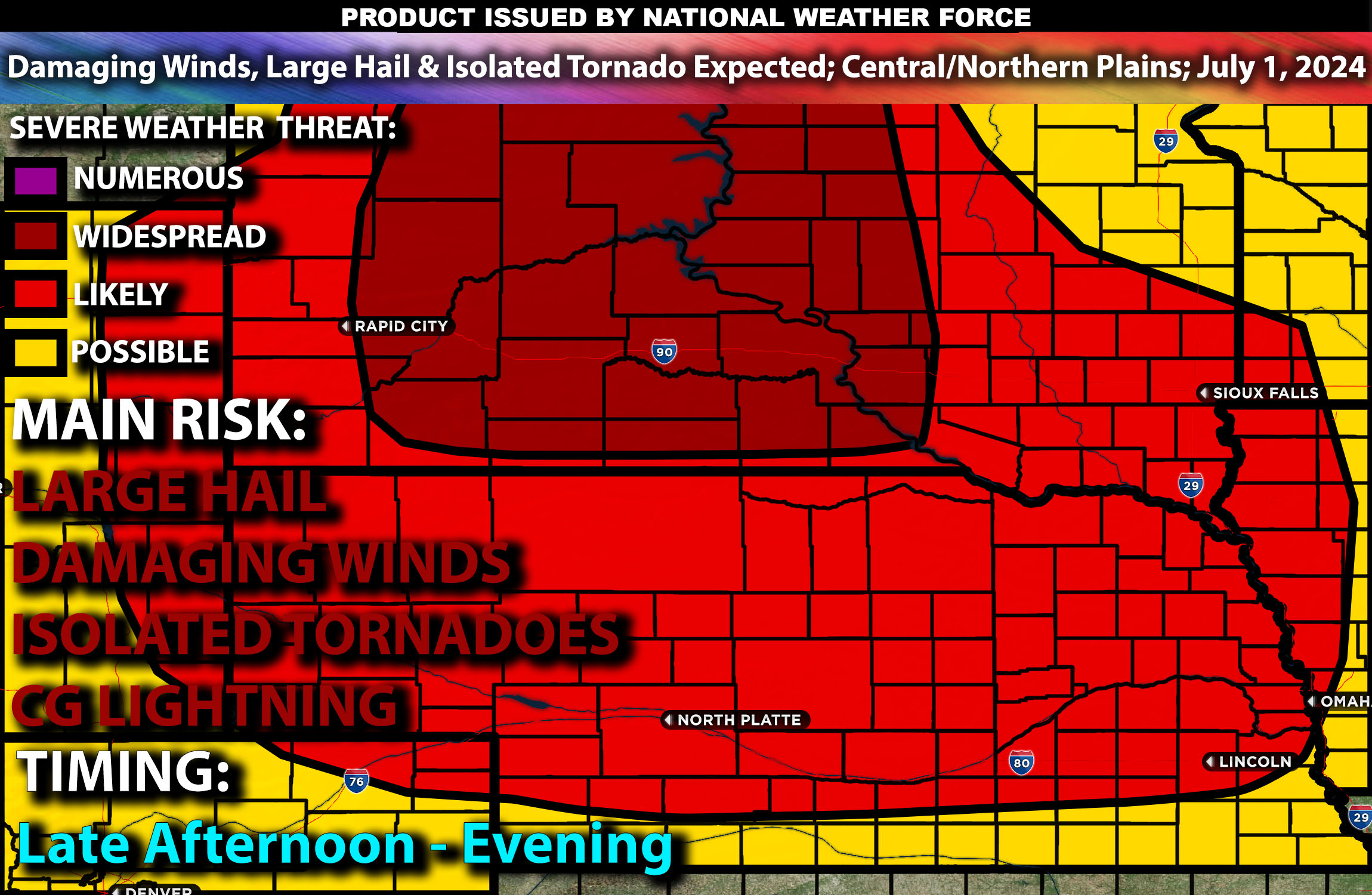
States and Cities Impacted: Nebraska (Omaha, Lincoln), South Dakota (Sioux Falls, Rapid City).
Detailed Forecast:
An upper-level trough will progress eastward into the northern and central Plains today. This movement will cause the upper-level ridge within the southern Plains to weaken and shift eastward. At the surface, an anticyclone in the East will broaden, pushing a surface boundary farther into the Southeast. A surface low is forecast to deepen near the CO/KS/NE border region, shifting eastward through the afternoon. This setup will enhance effective wind shear, with values around 45-55 knots, supporting the development of organized storm structures, including supercells.
At the surface, instability values are expected to reach 2500-3000 J/kg, particularly in southern and central Nebraska. The combination of the surface high to the east and the deepening surface cyclone in the central Plains will advect rich low-level moisture northward through the day into south-central and southeast Nebraska. This environment will support severe thunderstorms capable of producing large hail, damaging winds, and possibly a few tornadoes.
Timing:
The day will start with some form of convection in eastern Colorado/western Nebraska, which is expected to weaken and move east by early afternoon. Severe thunderstorms are likely to initiate by late afternoon near the surface low and northward-advancing warm front, with peak activity expected from mid-afternoon to early evening. These storms are expected to transition to linear modes, increasing the severe wind threat.
Main Impact: damaging winds, large hail, a few tornadoes and cg (cloud to ground) lightning).
Stay tuned for more updates.
Sina⚡⚡
With over a decade of experience in forecasting severe thunderstorms, this individual is a seasoned forecaster and developer. Their expertise in severe weather forecasting and computer science is entirely self-taught, complemented by a foundation in Atmospheric Science from UNCO and an IT background from WGU. They have dedicated their efforts to developing innovative tools that enhance the accuracy of analyzing large hail and tornadoes. As a significant contributor and partner at National Weather Force Innovations LLC, they have played a crucial role in providing accurate and timely information. Additionally, they have been instrumental in developing tools and organizing projects that focus on accuracy and performance, ensuring those affected are well-informed.