
Brief Outlook:
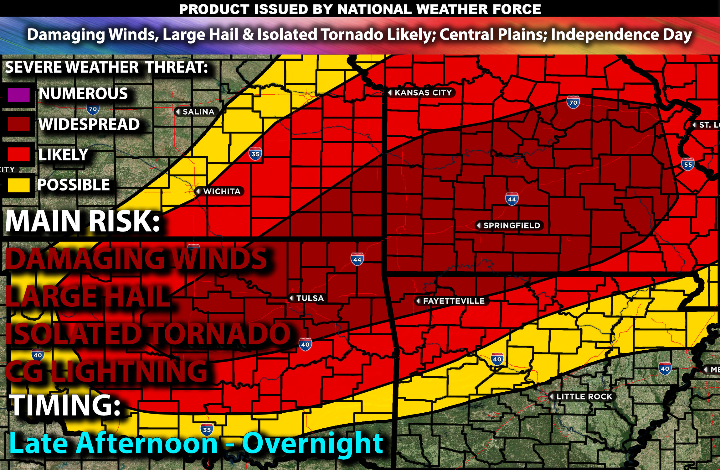
Severe thunderstorms are expected across parts of the Central Plains, with risks of damaging winds, hail, and a few isolated tornadoes possible on Independence Day. Check below for further details, timing and much more information.
States and Cities Impacted: Kansas (Topeka, Wichita), Oklahoma (Tulsa, Oklahoma City), Missouri (Springfield).
Detailed Forecast:
An upper-level trough over the northern and central Plains will deepen and develop into a closed low as it shifts east into the Upper Midwest and Mid-Mississippi Valley by Thursday night. Enhanced wind shear, with values around 40-50 knots in the 0-6 km layer, will support organized storm structures, including supercells capable of producing damaging winds, large hail, and potentially a few tornadoes.
At the surface, instability values are expected to reach 2000-3000 J/kg, particularly in eastern Kansas, northeast Oklahoma, and the Ozarks. A cold front will advance southeast across the central Plains, bringing a seasonally moist airmass with dewpoints in the 60s to low 70s. This interaction of the moist air with the advancing upper-level trough will create an environment conducive to severe thunderstorm development, especially during the late afternoon and evening hours.
Timing:
The day will start with calm conditions and potential morning cloud cover. By late afternoon, severe thunderstorms are expected to initiate near the surface trough and advancing front. Peak activity is expected from mid-afternoon to early evening, transitioning to more linear storm modes that will increase the severe wind threat. These storms are likely to diminish in intensity by late evening.
Main Impact: damaging winds, large hail, isolated tornado and lightning.
Stay tuned for more updates.
Sina⚡⚡
With over a decade of experience in forecasting severe thunderstorms, this individual is a seasoned forecaster and developer. Their expertise in severe weather forecasting and computer science is entirely self-taught, complemented by a foundation in Atmospheric Science from UNCO and an IT background from WGU. They have dedicated their efforts to developing innovative tools that enhance the accuracy of analyzing large hail and tornadoes. As a significant contributor, partner and Co-Owner at National Weather Force Innovations LLC (which own NWF, SCWF, AZWF and DWF), they have played a crucial role in providing accurate and timely information. Additionally, they have been instrumental in developing tools and organizing projects that focus on accuracy and performance, ensuring those affected are well-informed.