
Brief Outlook:
Severe thunderstorms are expected across parts of the Midwest on Monday. Storms are likely to begin impacting the region from late morning through the late afternoon. The main threats include damaging winds, with isolated severe gusts exceeding 75 mph possible, and a low probability of tornadoes, particularly in areas where bow echoes may form across the area. Check below for further details, timing and much more information.
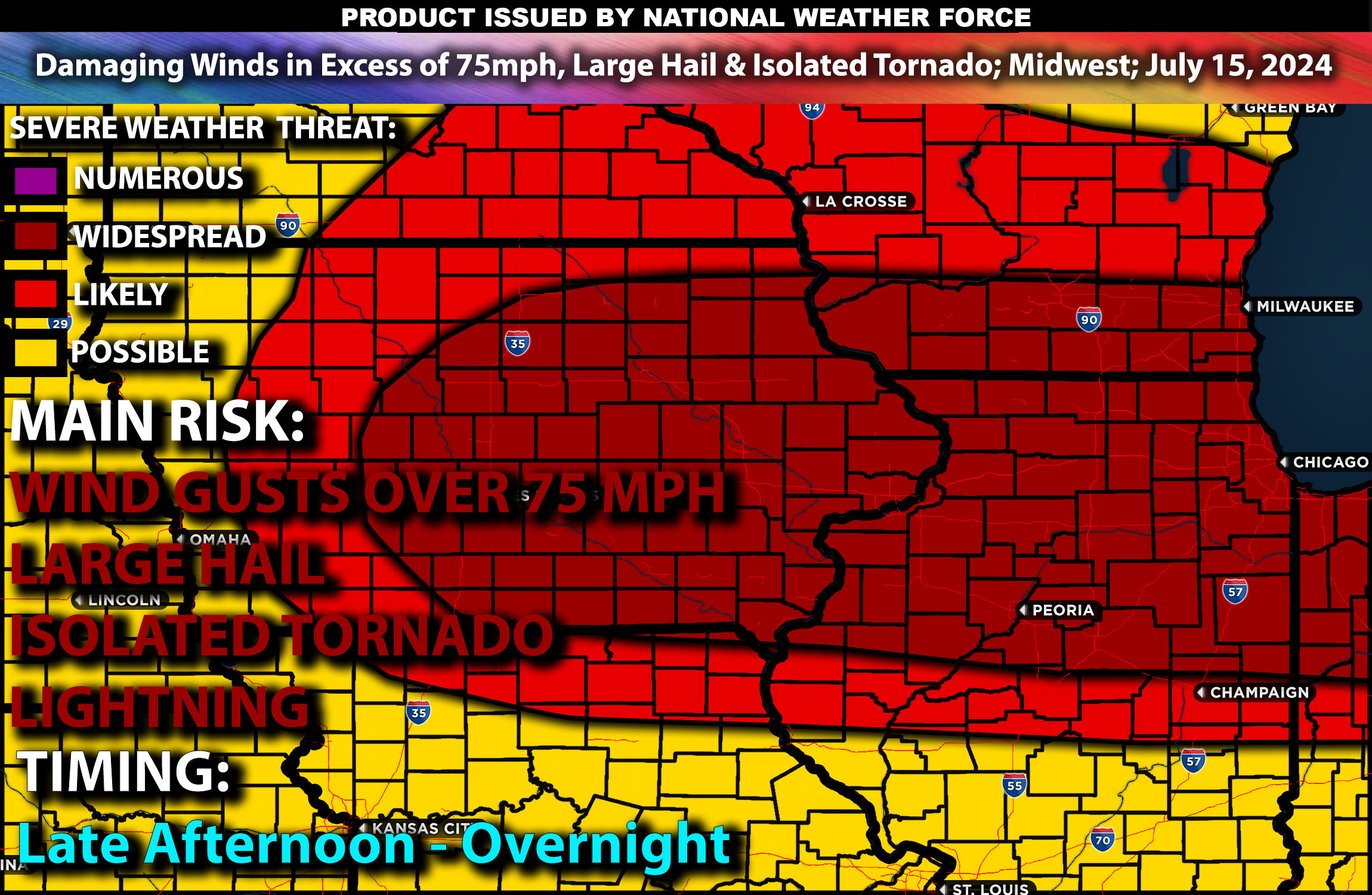
Regions Impacted: Midwest
States: Minnesota, Iowa, Wisconsin, Illinois
Cities: Minneapolis, Des Moines, Madison, Chicago, Peoria, Champaign
Detailed Forecast:
A complex weather scenario is anticipated with multiple rounds of thunderstorms potentially impacting the Midwest. By late morning to early afternoon, a significant mid-level weather disturbance will move across the region, interacting with a surface boundary. This interaction, combined with high moisture levels (dewpoints in the upper 70s°F) and strong surface heating, will create an environment with extreme instability (3500-4500 J/kg). This setup favors the development of a progressive bow-echo, which could produce a corridor of severe wind gusts and isolated tornadoes, especially in the enhanced risk area.
The upper-level pattern features broad cyclonic flow centered over the Upper Mississippi Valley, with multiple mid-level impulses rotating through this flow. A surface cold front will advance southeastward through the Midwest. The combination of strong mid-level westerly winds, low-level shear, and high instability will likely support severe thunderstorm development. Convective initiation is expected along a west-to-east oriented baroclinic zone, with the potential for storms to organize into a bow-echo system. This could lead to widespread damaging winds, with some gusts exceeding 75 mph, and a few isolated tornadoes.
Timing:
Thunderstorms are expected to begin in Minnesota and Iowa late in the morning around 11 AM, moving southeastward into Wisconsin by early afternoon. The storms will likely impact major cities like Minneapolis and Des Moines between 12 PM and 3 PM. As the afternoon progresses, storms will continue moving southeastward, reaching Madison by late afternoon around 4 PM. Storm activity should gradually diminish by late evening as instability decreases, tapering off by 8 PM.
Main Impact: damaging winds in excess of 75mph, large hail, isolated tornado & lightning.
Stay tuned for more updates.
Sina⚡⚡