
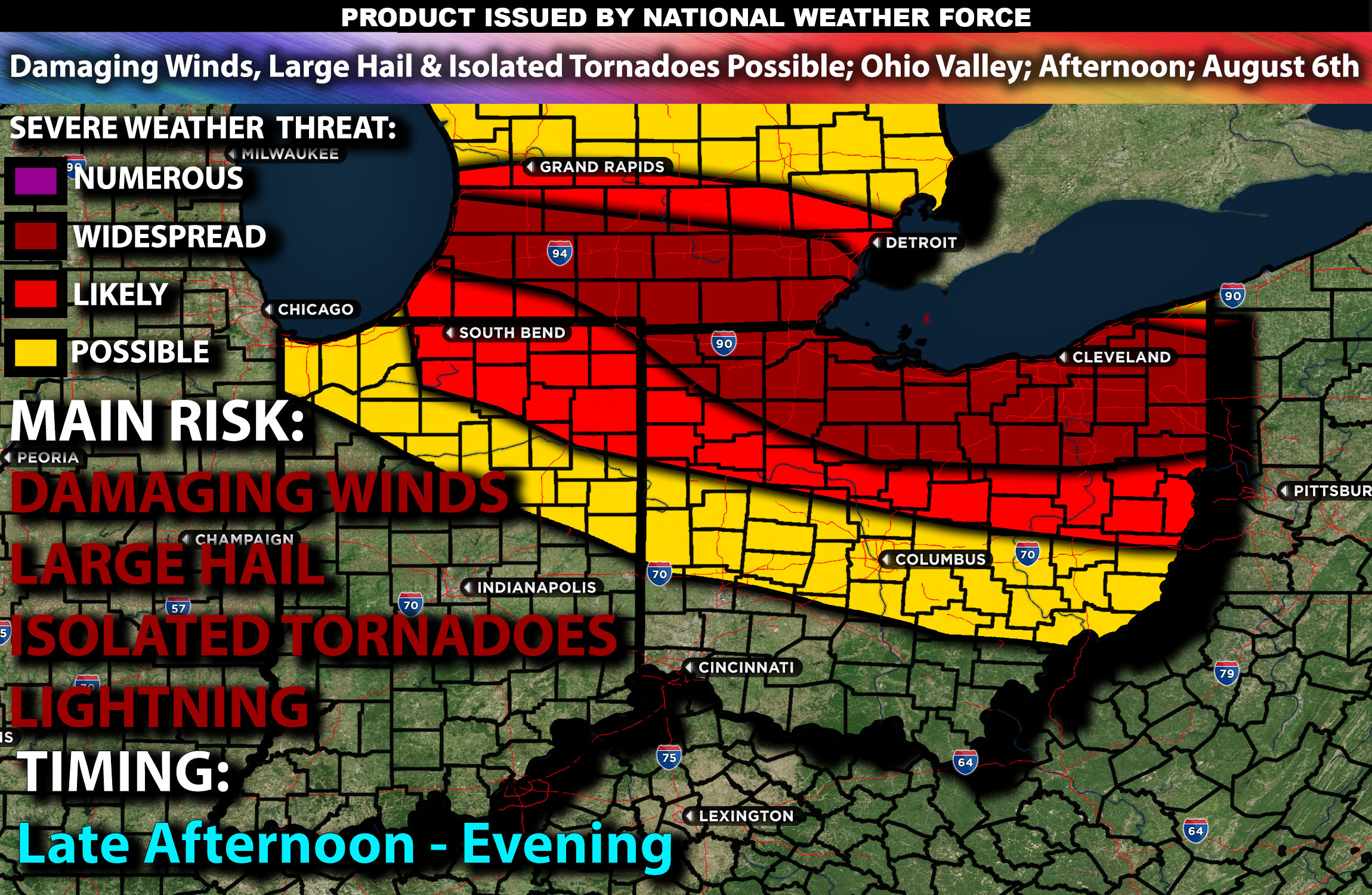
Brief Outlook:
Severe thunderstorms are expected in parts of Indiana and especially northern parts of Ohio & southern Michigan area from the afternoon into the evening. The main risk with these storms will be damaging winds, large hail, and isolated tornadoes. Check below for further details on timing and much more.
Region Impacted: Indiana and Ohio
States and Cities Impacted: Indiana (Indianapolis, Fort Wayne, Evansville), Ohio (Columbus, Cleveland, Cincinnati).
Upper-Level Dynamics:
A prominent east-west front will stretch from northern Illinois to the southern border of lower Michigan towards Lake Erie by midday, with a moist and unstable air mass to the south. An upper-level shortwave trough will move toward the area from the northwest, enhancing lift and promoting thunderstorm development. Enhanced wind shear, with values around 30-40 knots in the 0-6 km layer, will support organized storm structures, including supercells.
Surface Conditions:
At the surface, instability values are expected to reach 1500-2500 J/kg across Indiana and Ohio. Low-level moisture with surface dewpoints in the upper 60s to low 70s will contribute to significant instability. Effective shear will support supercell development, and moderate mid-level lapse rates will promote strong updrafts. At the same time, an MCV with multiple bowing segments is anticipated to form around the evening. Storms are expected to be initially discrete, with a potential transition to clusters or lines, capable of producing large hail and damaging winds. Isolated tornadoes are possible, especially in the northern Ohio and southern Michigan regions where there will be enhanced shear with height.
Timing:
Storms are expected to initiate by mid to late afternoon in northern Indiana, moving into Ohio by early evening. At the same time, an MCV with multiple bowing segments is anticipated to form around the evening. Peak activity will likely occur from late afternoon through the evening, with the most severe storms expected during this period. The main risk with these storms will be damaging winds with potential embedded tornadoes, especially during the evening hours before transitioning more into bowing segments with damaging winds being the main risk.
Main Impact: damaging winds, isolated tornado and lightning.
Sina⚡⚡
Managing Partner and Lead Forecaster of NWF Innovations & NWF Networks