
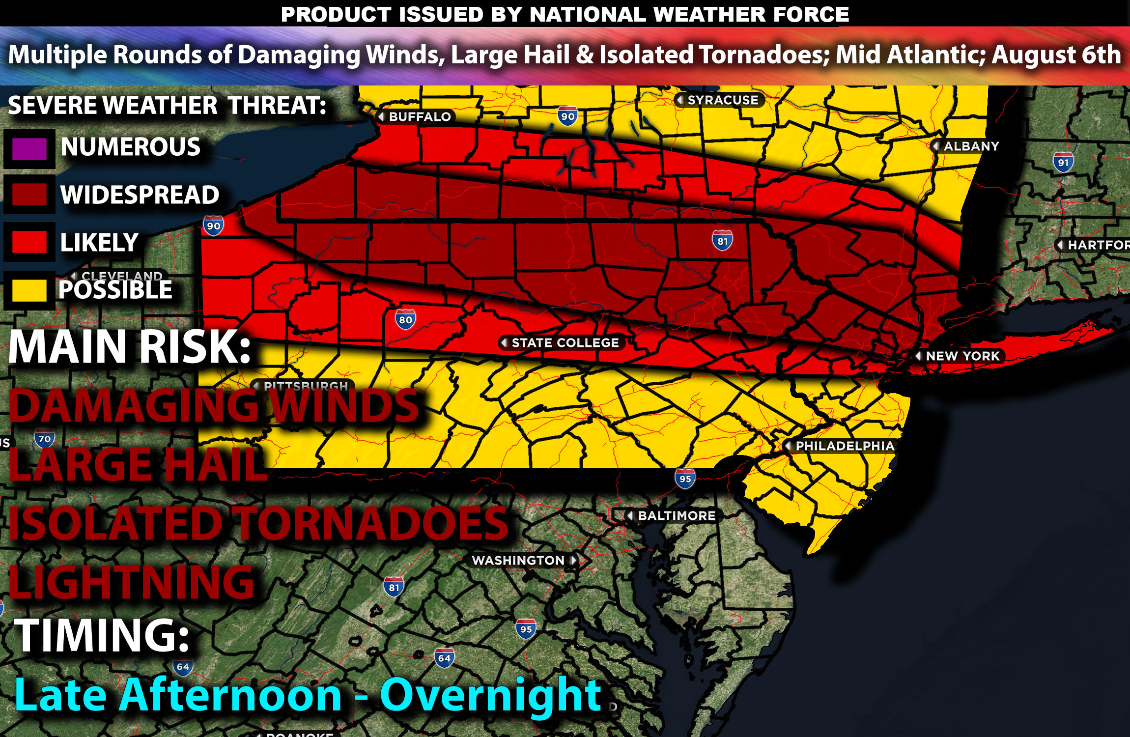
Brief Outlook:
Severe thunderstorms are expected across parts of the Mid-Atlantic, particularly in Pennsylvania and New York, from the afternoon into the evening then also overnight. The main risk with these storms will be damaging winds, marginally large hail. Check below for further details on timing and much more.
Region Impacted: Mid-Atlantic
States and Cities Impacted:Pennsylvania (Philadelphia, Pittsburgh, Harrisburg), New Jersey (Trenton), New York (New York City).
Upper-Level Dynamics:
A shortwave trough will slowly progress across the Ohio and Tennessee Valleys, moving towards the Mid-Atlantic by late in the day. An upper-level low over the region will enhance mid-level flow, resulting in strong vertical wind shear with values around 25-35 knots in the 0-6 km layer. This setup will support organized storm structures, including supercells.
Surface Conditions:
At the surface, an east-west front will stretch from northern IL area across PA with a very moist airmass to the south of it. At the same time, instability values are expected to reach 1500-2500 J/kg across Pennsylvania and New York. Dewpoints in the low 70s will contribute to significant instability, creating a moist and unstable environment. Effective shear will support supercell development, while moderate mid-level lapse rates will promote strong updrafts in storms. Storms are expected to be initially discrete before potentially forming clusters or lines, capable of producing large hail and damaging winds. Isolated tornadoes are also possible especially in western PA regions due to the favorable shear profiles however not the main risk with these storms.
Timing:
Multiple rounds of severe thunderstorms are expected to initiate by late afternoon in western Pennsylvania, moving eastward through the state and into New York, including areas such as NYC, by late evening/overnight. Due to the nature of the dynamics, multiple waves of storms are expected to move through the Pennsylvania area, with scattered cells across the front extending from Pennsylvania through New York. Multiple cells will form across NYC too before a bow segment moves through overnight, progressing from Pennsylvania into NYC. Peak activity will likely occur from late afternoon through the evening, with the most severe storms expected during this period. However, throughout the night, more showers and storms are anticipated due to the ongoing dynamics, and these storms are expected to become less severe over time.
Main Impact: localized large hail, damaging winds, isolated tornadoes and lightning.
Stay tuned for more updates.
Sina⚡⚡
Managing Partner and Lead Forecaster of NWF Innovations & NWF Networks