
 Brief Outlook:
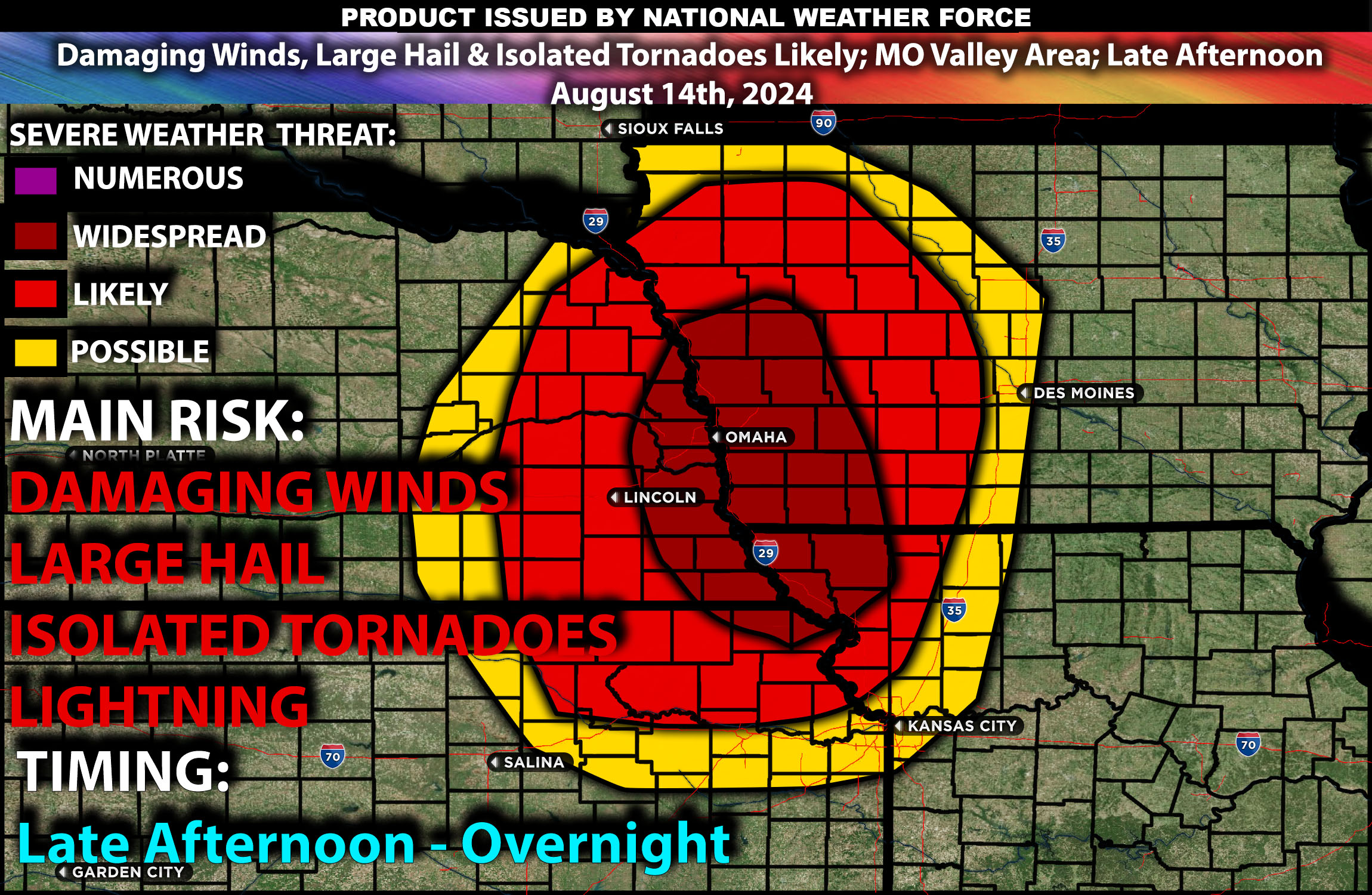
Scattered severe thunderstorms are expected late this afternoon and evening across the Missouri Valley, particularly impacting parts of eastern Kansas, southeastern Nebraska, southwestern Iowa, and northwestern Missouri. These storms will be capable of producing damaging winds, large hail, and isolated tornadoes.
Region Impacted: Missouri Valley
Counties and Cities Impacted:
Kansas: Johnson County (Overland Park, Olathe), Douglas County (Lawrence)
Nebraska: Lancaster County (Lincoln), Sarpy County (Bellevue)
Iowa: Pottawattamie County (Council Bluffs), Mills County (Glenwood)
Missouri: Platte County (Kansas City), Buchanan County (St. Joseph)
Upper-Level Dynamics/Forecast:
An upper-level shortwave trough will move eastward across the northern and central Plains, leading to the development of a more organized thunderstorm complex over the Missouri Valley. Enhanced southerly low-level flow, combined with moderate mid-level westerlies (30-40 knots), will provide sufficient wind shear to support supercell formation in the afternoon and evening. These upper-level conditions are conducive to the development of severe thunderstorms capable of producing large hail and damaging winds.
Surface Conditions:
At the surface, instability values are expected to reach 1500-2500 J/kg across the Missouri Valley, driven by the hot and humid conditions. Surface heating combined with a moist low-level airmass will create an environment primed for thunderstorm development. The surface cold front moving southeastward across the central Plains, along with a remnant outflow boundary, will serve as focal points for storm initiation. Effective shear will support the initial development of discrete supercells, with the potential for very large hail (up to 2-2.5 inches in diameter) and isolated tornadoes. As the evening progresses, storms are expected to merge into clusters, with damaging winds becoming the primary threat. The highest risk for any tornadoes mainly isolated will be in southwestern IA/southeastern/eastern NE area with the highest low level shear.
Timing:
Thunderstorms are expected to initiate by late afternoon (around 4-6 PM CDT) in eastern Kansas and southeastern Nebraska, with activity spreading eastward into southwestern Iowa and northwestern Missouri by early evening and continue as a line overnight with the risk transitioning to damaging winds. Peak intensity will likely occur from late afternoon through the evening, with the most severe storms expected during this period. The storms are likely to weaken gradually overnight as they move eastward.
Main Impact: damaging winds, isolated tornado and lightning.
Stay tuned for more updates.
Sina⚡⚡
Co-Owner/CTO and Lead Forecaster of NWF Innovations & NWF Networks