
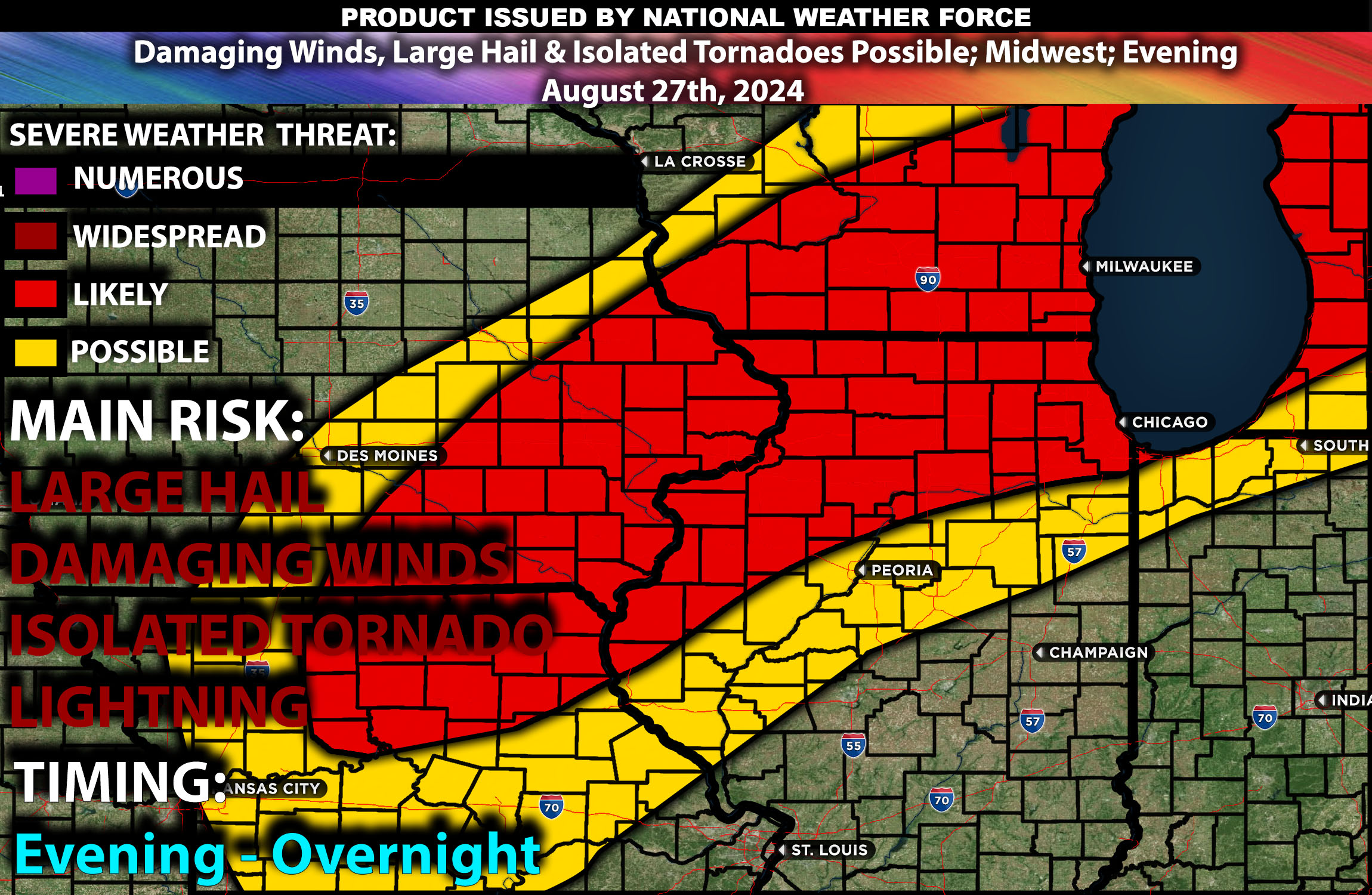
Brief Outlook:
Severe thunderstorms are expected across parts of the Midwest much later today, particularly impacting areas in northern Illinois, eastern Iowa, and southern Wisconsin. These storms will be capable of producing damaging winds, large hail, and isolated tornadoes.
Region Impacted: Northern Illinois, Eastern Iowa, Southern Wisconsin
Counties and Cities Impacted:
- Illinois: Cook County (Chicago), DuPage County (Naperville), Rock Island County (Moline)
- Iowa: Scott County (Davenport), Linn County (Cedar Rapids), Dubuque County (Dubuque)
- Wisconsin: Dane County (Madison), Rock County (Janesville), Milwaukee County (Milwaukee)
Upper-Level Dynamics/Forecast:
An upper-level shortwave trough will continue to move eastward across the central Plains, enhancing mid-level westerly flow across the Midwest. This trough, combined with a strong jet streak aloft, will provide the necessary lift and shear to support organized severe thunderstorms. Wind speeds at the mid-levels are expected to range between 40-50 knots, which will help with storm organization and the potential development of supercells.
Surface Conditions:
At the surface, instability values are expected to reach 2500-4000 J/kg across the impacted regions, driven by very high temperatures and ample low-level moisture with dewpoints in the upper 60s to low 70s. The presence of a cold front moving southeastward through the Midwest will serve as the primary trigger for storm initiation. Effective shear will support the development of discrete supercells initially, which may produce large hail and isolated tornadoes. As the evening progresses into the night, storms are expected to merge into larger clusters or lines, with damaging winds becoming the primary threat. Steep mid-level lapse rates will further enhance the potential for severe weather.
Timing:
Storms are expected to initiate by late afternoon (around 5-7 PM CDT) in eastern Iowa and northern Illinois, with activity increasing in coverage by early evening. Peak intensity is likely to occur from the evening through the overnight hours in multiple rounds scattered, with the strongest storms expected during this period. The storms are likely to weaken gradually overnight as they move eastward.
Main Impact: damaging winds, very large hail, isolated tornadoes and lightning.
Stay tuned for more updates.
Sina⚡⚡
Co-Owner/CTO and Lead Forecaster of NWF Innovations & NWF Networks