
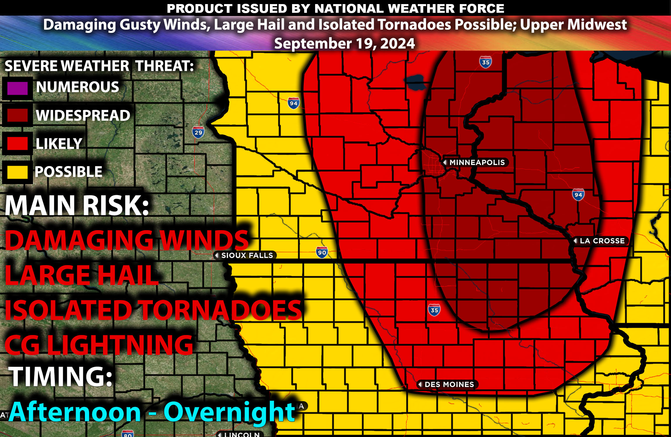
Brief Outlook:
Scattered severe thunderstorms are expected across central and eastern Minnesota, northern Iowa, and western Wisconsin from mid-afternoon to mid-evening. The primary threats include large hail, damaging winds, and a few isolated tornadoes. Cities like Minneapolis, St. Paul, Rochester, and Duluth in Minnesota, along with nearby regions in Iowa and Wisconsin, could see impact with these storms.
Detailed Forecast:
In the upper atmosphere, a strong vertically stacked cyclone over the North Dakota, Saskatchewan, and Manitoba border is forecast to move northeast, bringing enhanced mid-level flow (35-50 knots at 700-500 mb). This system will be accompanied by a cold front progressing eastward across Minnesota and Iowa, setting the stage for storm initiation by afternoon. The front will provide enough lift to generate thunderstorms due to favorable shear and instability conditions.
At the Surface:
Moderate to high instability (MLCAPE ranging from 2000 to 3000 J/kg) is expected along a narrow plume of moisture with mid-to-upper 60s dew points. Effective shear values will be sufficient to support well-organized supercells, leading to large hail and isolated damaging winds. Low-level shear, along with curved hodographs, increases the risk of tornadoes. Mid-level lapse rates (change in temperature with height) are forecasted to remain steep (around 7-8°C/km), supporting storm development and maturity. Initially, discrete supercells will be possible, but some storm clusters may evolve later in the day.
Timing: Storms are expected to initiate by mid-afternoon (around 3 PM CDT), with conditions becoming increasingly favorable for severe weather. The peak of severe activity, including supercells capable of producing tornadoes and large hail, is anticipated between 4 and 8 PM CDT. Severe weather should begin to taper off by mid-evening (after 8 PM CDT), with the storms weakening as they move into less favorable environments overnight.
Main Impact: severe wind gusts, large hail, and isolated tornadoes.
Stay tuned for more updates.
Sina
Co-Owner/CTO and Lead Forecaster of NWF Innovations & NWF Networks