
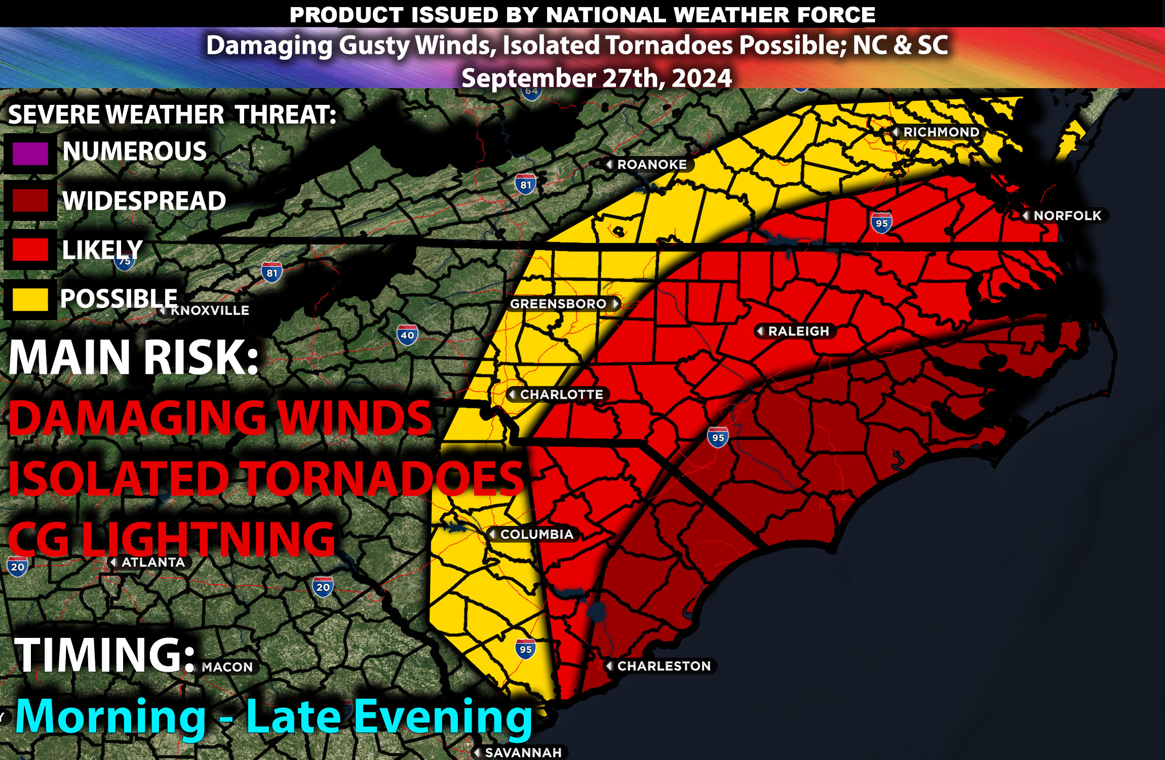
Brief Outlook:
A severe weather outbreak is expected across the Carolinas on Friday, September 27, 2024. Cities including Charlotte, Raleigh, Greensboro, and Columbia are at risk for severe thunderstorms capable of producing damaging winds, and isolated tornadoes. Counties such as Mecklenburg, Wake, Guilford, and Richland should prepare for significant weather impacts.
Upper-Level Forecast:
A strong mid-level trough is forecasted to move eastward across the Mississippi Valley into the Southeast. This system will bring enhanced wind speeds in the upper levels, creating significant wind shear conducive to severe thunderstorm development. A pronounced jet streak at 250 mb will enhance divergence aloft, promoting vigorous upward motion. Additionally, a shortwave trough embedded within the larger system will provide extra lift, increasing the potential for organized convection.
Surface Forecast Conditions:
At the surface, a cold front is expected to advance into the region, interacting with a warm and moist air mass from the Gulf of Mexico. Instability values (CAPE) are projected to reach between 2000-2500 J/kg by the afternoon, indicating a highly unstable atmosphere. Effective shear values are anticipated to be around 40-50 knots, with low-level shear near 25 knots, supporting the development of supercell thunderstorms. Mid-level lapse rates are expected to be around 7.0°C/km, which is sufficient for large hail formation. The storms are likely to initiate as discrete cells but may evolve into a linear system as the evening progresses.
Timing:
The atmospheric ingredients are expected to come together by late morning. Initial storm development is anticipated around 1:00 PM ET in western regions like Asheville and Greenville. As the afternoon progresses, storms will intensify and move eastward, impacting cities such as Charlotte and Columbia by approximately 3:00 PM ET. By early evening, around 6:00 PM ET, areas including Raleigh and Fayetteville should expect severe weather conditions. The peak intensity of the storms is likely between 4:00 PM and 8:00 PM ET. The severe threat is expected to diminish after midnight as the system moves offshore.
Main impact: isolated tornadoes, damaging gusty winds, and heavy rainfall.
Sina⚡⚡
Co-Owner/CTO and Lead Forecaster of NWF Innovations & NWF Networks